चित्र:1922 Index of Great Trigonometrical Survey of India.jpg

ओरिजनल फाइल (५,५६० × ४,४४८ पिक्सेल, फाइल साइज: १६.५४ MB, MIME टाइप: image/jpeg)
सारांश
| Description1922 Index of Great Trigonometrical Survey of India.jpg |
Index to the Great Trigonometrical Survey of India (1922). India is shown on a 1-degree grid of green lines. The blue triangles indicate the Great Trigonometrical w:triangulation measurements. Triangulation series are indicated by a number in parentheses. These series are described in the table at the bottom left. The red dash-dot lines are telegraph longitude area. Among the many accomplishments of the Survey were the demarcation of the British territories in India and the measurement of the height of the Himalayan giants: Everest, K2, and Kanchenjunga. |
|||||||||
| तारीख | ||||||||||
| स्रोत | Report of the Survey of India for 1921–22 | |||||||||
| Creator |
Survey of India, Government of India |
|||||||||
| Geotemporal data | ||||||||||
| Bounding box |
|
|||||||||
| Georeferencing | ||||||||||

लाइसेंसिंग
| Public domainPublic domainfalsefalse |

|
This work is in the public domain in India because its term of copyright has expired or it is ineligible for copyright.
The Indian Copyright Act applies in India to works first published in India. According to the Indian Copyright Act, 1957, as amended up to Act No. 27 of 2012 (Chapter V, Section 25):
 You must also include a United States public domain tag to indicate why this work is in the public domain in the United States. You must also include a United States public domain tag to indicate why this work is in the public domain in the United States.
|
 |
| Public domainPublic domainfalsefalse |
|
|
This work is in the public domain in the United States because it was published (or registered with the U.S. Copyright Office) before January 1, 1931.
Public domain works must be out of copyright in both the United States and in the source country of the work in order to be hosted on the Commons. If the work is not a U.S. work, the file must have an additional copyright tag indicating the copyright status in the source country.
Note: This tag should not be used for sound recordings.PD-1923Public domain in the United States//commons.wikimedia.org/wiki/File:1922_Index_of_Great_Trigonometrical_Survey_of_India.jpg |
Assessment
|


|
This image has been selected as picture of the day on Wikimedia Commons for 14 August 2027. It will be captioned as follows: English: 1922 index to the Great Trigonometrical Survey of India, a project that aimed to survey the entire Indian subcontinent with scientific precision. The Survey demarcated the British territories in the subcontinent and measured the height of Himalayan giants such as Everest, K2, and Kangchenjunga. Tonight marks 80 years since the end of British colonial rule in the Indian subcontinent in 1947 and the accompanying partition of India along religious lines into India and Pakistan (from which Bangladesh later seceded in 1971). The partition resulted in an unprecedented displacement of between 12 and 20 million people, with large-scale violence causing the deaths of between several hundred thousand and two million people, according to estimates. Other languages:
English: 1922 index to the Great Trigonometrical Survey of India, a project that aimed to survey the entire Indian subcontinent with scientific precision. The Survey demarcated the British territories in the subcontinent and measured the height of Himalayan giants such as Everest, K2, and Kangchenjunga. Tonight marks 80 years since the end of British colonial rule in the Indian subcontinent in 1947 and the accompanying partition of India along religious lines into India and Pakistan (from which Bangladesh later seceded in 1971). The partition resulted in an unprecedented displacement of between 12 and 20 million people, with large-scale violence causing the deaths of between several hundred thousand and two million people, according to estimates. |
Captions
फाइल के इतिहास
ओ समय ई फाइल कइसन लउके ई देखे खातिर कौनों तारीख/समय पर क्लिक करीं।
| तारीख/समय | चिप्पी रूप | डाइमेंशन | प्रयोगकर्ता | टिप्पणी | |
|---|---|---|---|---|---|
| वर्तमान | १४:२९, २६ सितंबर २०१३ | 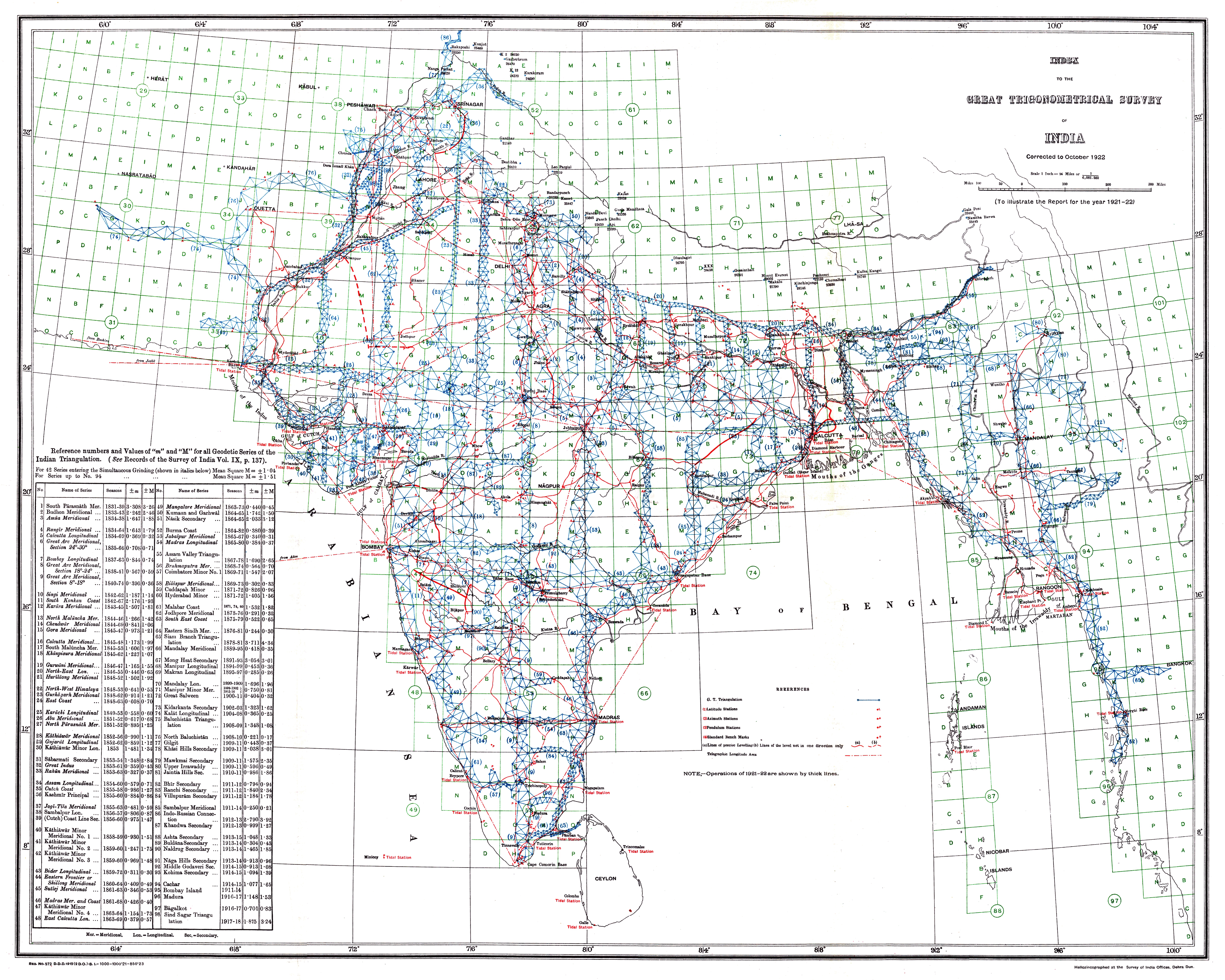 | ५,५६० × ४,४४८ (१६.५४ MB) | smartcommons>Shyamal | {{Information |Description=Index to the Great Trigonometrical Survey of India (1922) |Source=Report of the Survey of India for 1921-22 |Date=1922 |Author=Survey of India, Government of India |Permission={{PD-1923}} |other_versions= }} [[Category:Maps... |
फाइल के उपयोग
कौनों पन्ना नइखे जवन ए फाइल के इस्तेमाल करत होखे।
