चित्र:2011 Census Scheduled Tribes distribution map India by state and union territory.svg

ओरिजनल फाइल (एसवीजी फाइल, नॉमिनली १,५०० x १,६१५ पिक्सल, फाइल के आकार: १.४ MB)

सारांश
| बिबरण2011 Census Scheduled Tribes distribution map India by state and union territory.svg |
English: This demographic map shows Scheduled Tribes (ST) as a percent of each state and union territory's population per 2011 Census of India. Mizoram and Lakshadweep had the highest percentage Tribal populations in 2011 among all Indian states/UT (nearly 95%), while Punjab and Haryana had 0%.
Scheduled Tribes are also known as Ādivāsīs. Adivasi is an umbrella term for a heterogeneous set of ethnic and tribal groups who inhabit different parts of India. Different tribes live in mountainous northeastern states, dry areas of western states, the forests of central and eastern states, the islands of Bay of Bengal and Arabian Sea, as well as other areas. Officially recognized by the Indian government as Scheduled Tribes in the Fifth Schedule of the en:Constitution of India, they are often grouped together with scheduled castes in the category "en:Scheduled Castes and Tribes", which is eligible for certain affirmative action measures. Data Source: Census of India 2011, Primary Census Abstract - Scheduled castes and scheduled tribes, Office of the Registrar General & Census Commissioner, India (October 28 2013). The data can be viewed in a Powerpoint presentation on a Government of India Census website here. The state and disputed national borders SVG code used to create this map is a derivative work of File:India literacy rate map en.svg available on wikimedia commons. |
| तारीख | |
| स्रोत | आपन रचना |
| लेखक | M Tracy Hunter |

लाइसेंसिंग


- आप फ्री बानी:
- साझा करे खातिर – रचना के नकल करे, बाँटे आ दुसरी जगह भेजे खातिर
- रीमिक्स करे खातिर – काम के अपनी हिसाब से बनावे खातिर
- नीचे दिहल कारणन की तहत:
- एट्रीब्यूशन – लाइसेंस के कड़ी दे के उचित श्रेय (क्रेडिट) दिहल जरूरी बा आ अगर कौनों बदलाव कइल गइल बा तब ओहू के बतावल जाए के चाहीं। आप ई काम कौनों उचित तरीका से क सकत बानी, बाकी ई न झलके के चाहीं की जेकरा लगे लाइसेंस बा ऊ राउर चाहे राउर काम के समर्थन करत बाटे या सही बतावत बा।
- शेयर अलाइक (share alike) – अगर आप एह सामग्री के आधार बना के कुछ रिमिक्स करत बानी, रूप बदलाव करत बानी, चाहे कुछ जोड़ के सामग्री के बढ़ावत बानी, आपके आपन योगदान ठीक एही या कंपेटिबल लाइसेंस जइसन कि ओरिजनल बाटे, के तहत होखे के चाहीं।
Captions
फाइल के इतिहास
ओ समय ई फाइल कइसन लउके ई देखे खातिर कौनों तारीख/समय पर क्लिक करीं।
| तारीख/समय | चिप्पी रूप | डाइमेंशन | प्रयोगकर्ता | टिप्पणी | |
|---|---|---|---|---|---|
| वर्तमान | ०२:५१, २७ जनवरी २०२१ | 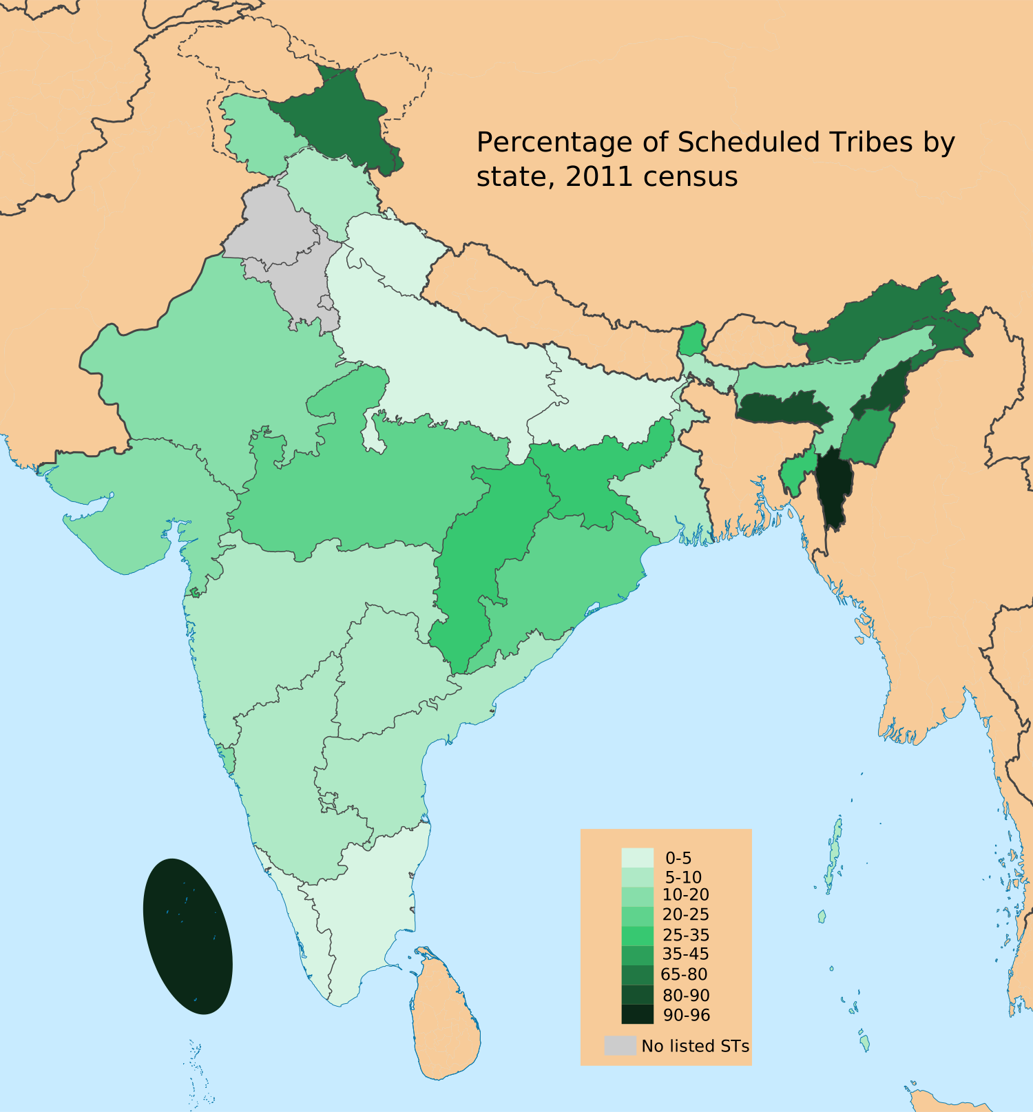 | १,५०० × १,६१५ (१.४ MB) | smartcommons>C1MM | Relabeled to better show diversity |
फाइल के उपयोग
कौनों पन्ना नइखे जवन ए फाइल के इस्तेमाल करत होखे।
