चित्र:Asia 400ad.jpg

ए नमूना के साइज: २२० × १३४ पिक्सेल. अउरी रिजोल्यूशन: ३२० × १९५ पिक्सेल | १,९९० × १,२११ पिक्सेल.
ओरिजनल फाइल (१,९९० × १,२११ पिक्सेल, फाइल साइज: ७९० KB, MIME टाइप: image/jpeg)

|
This historical map image could be re-created using vector graphics as a SVG file. This has several advantages; see Commons:Media for cleanup for more information. If a SVG form of this image is available, please upload it and afterwards replace this template with
{{vector version available|new image name}}.It is recommended to name the SVG file “Asia 400ad.svg”—then the template Vector version available (or Vva) does not need the new image name parameter. |


सारांश
| बिबरणAsia 400ad.jpg |
English: Asia in 400 AD. Displayed among others: Kushan Empire, Sassanid Empire, Gupta Empire, Huns, Tai peoples, Kidarites |
| स्रोत | URL: http://www.ThomasLessman.com/History/images/East-Hem_400ad.jpg |
| लेखक | Thomas A. Lessman, en:User:Talessman |
| परमीशन (एह फाइल के दुबारा इस्तेमाल) |
Image was created by me (Thomas Lessman) based on map of Eastern Hemisphere in 400 AD. Image is free for public and/or educational use. I would appreciate a mention if this image is used elsewhere. If anyone is interested in helping further this work, please contact Thomas Lessman at [email protected]. |
| Other versions | Derivative works of this file: |

.jpg)


|
|
This historical map image could be re-created using vector graphics as a SVG file. This has several advantages; see Commons:Media for cleanup for more information. If a SVG form of this image is available, please upload it and afterwards replace this template with
{{vector version available|new image name}}.It is recommended to name the SVG file “Asia 400ad.svg”—then the template Vector version available (or Vva) does not need the new image name parameter. |
लाइसेंसिंग
  
|
ई फाइल Creative Commons Attribution-Share Alike 3.0 Unported लाइसेंस की तहत लाइसेंसी बा। Subject to disclaimers. | |
| ||
| This licensing tag was added to this file as part of the GFDL licensing update.http://creativecommons.org/licenses/by-sa/3.0/CC BY-SA 3.0Creative Commons Attribution-Share Alike 3.0truetrue |

|
जीएनयू फ्री डाकुमेंटेशन लाइसेंस, वर्जन 1.2 या फिर कौनो भी बाद के प्रकाशित फ्री साफ्टवेयर फाउंडेशन लाइसेंस के शर्त के तहत, एह डाकुमेंट के नकल करे, बितरण करे आ/भा बदलाव करे के परमीशन दिहल गइल बा; एह में इनवैरिएंट खंड सभ नइखे शामिल, मुखपृष्ट के पाठ नइखे शामिल, आ बैक-कभर के पाठ नइखे शामिल। लाइसेंस के एगो प्रति जीएनयू फ्री डाकुमेंटेशन लाइसेंस नाँव के खंड में दिहल गइल बा। Subject to disclaimers.http://www.gnu.org/copyleft/fdl.htmlGFDLGNU Free Documentation Licensetruetrue |
Captions
Add a one-line explanation of what this file represents
फाइल के इतिहास
ओ समय ई फाइल कइसन लउके ई देखे खातिर कौनों तारीख/समय पर क्लिक करीं।
| तारीख/समय | चिप्पी रूप | डाइमेंशन | प्रयोगकर्ता | टिप्पणी | |
|---|---|---|---|---|---|
| वर्तमान | २३:५७, ६ अप्रैल २००८ | 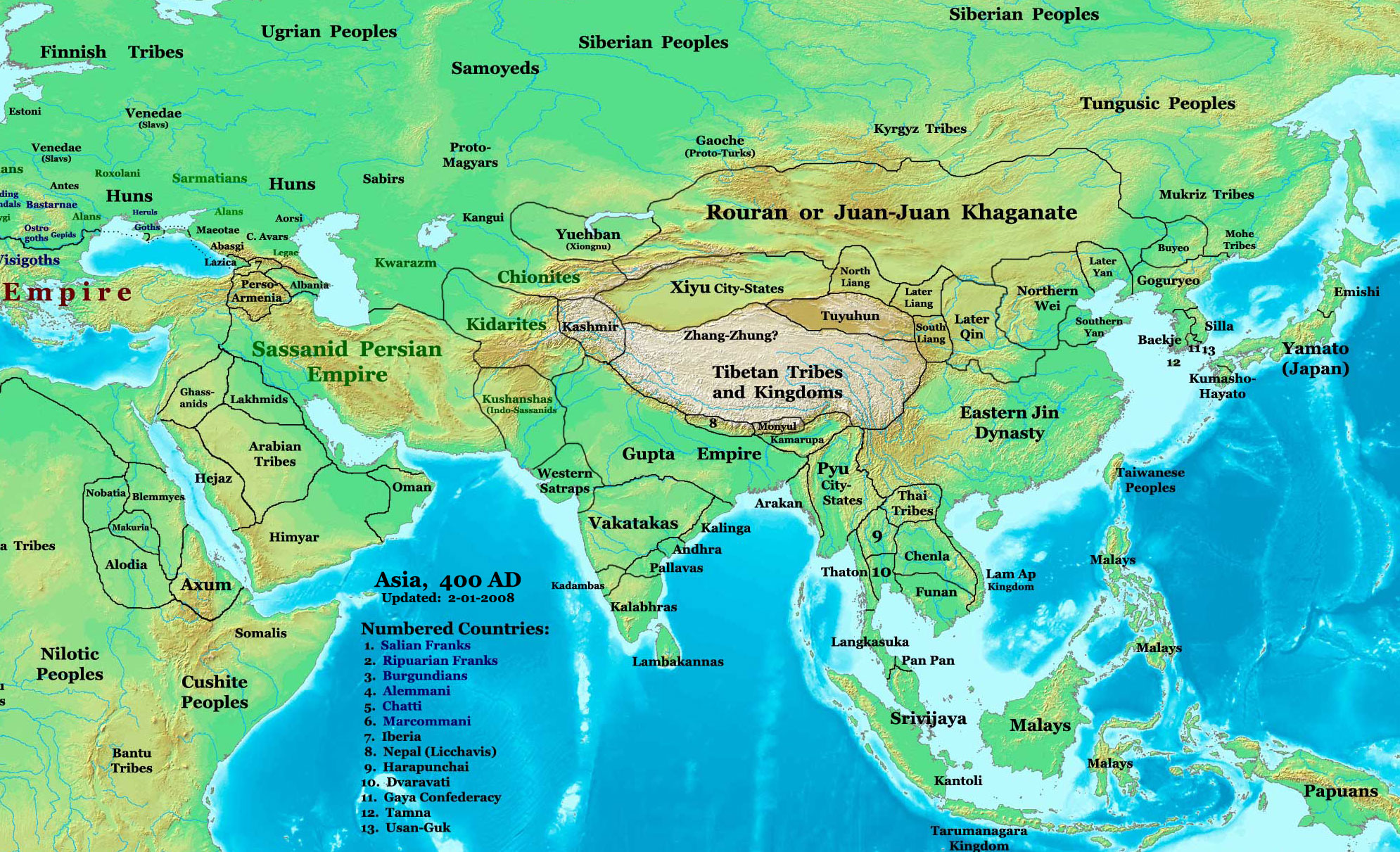 | १,९९० × १,२११ (७९० KB) | smartcommons>Guillem d'Occam | Author: Thomas A. Lessman. Source URL: [http://www.ThomasLessman.com/History/images/East-Hem_400ad.jpg]. Image was created by me (Thomas Lessman) based on map of Eastern Hemisphere in 400 AD. Image is free for public and/or educational use. I would appr |
फाइल के उपयोग
कौनों पन्ना नइखे जवन ए फाइल के इस्तेमाल करत होखे।
