चित्र:Chagatai Khanate map en.svg

ओरिजनल फाइल (एसवीजी फाइल, नॉमिनली ८११ x ६४६ पिक्सल, फाइल के आकार: ४६८ KB)

सारांश
| बिबरणChagatai Khanate map en.svg |
A A map of the Chagatai Khanate in the late 13th century. The grey lines represent modern international borders. The blue represent rivers. This map uses a Lambert azimuthal equal-area projection. |
| तारीख | |
| स्रोत | आपन रचना |
| लेखक | MapMaster |
| Other versions |
Derivative works of this file: Chagatai Khanate map Masry.PNG A locator map (without text) can be found here. See also Image:Golden Horde 1389.svg |


References
- Barnes, Ian; Robert Hudson (1998) The History Atlas of Asia, MacMillan, p. 87.
- Barraclough, Geoffrey (1993) The Times Atlas of World History, 4th Edition, Hammond World Atlas Corporation, ISBN 0723005346, p. 127.
- Facts on File (2002) Historical Maps on File: Ringbound, Facts on File, 2nd Edition, ISBN 081604600X, p. 2.27 "Mongol Invasions of Russian, 12th-13th Centuries".
- Map of the Mongol Empire archive copy at the Wayback Machine, Los Angeles County Museum of Art, accessed 8 July 2008.
These references do not completely agree on the borders of the Khanate. The Facts on File map, for example, shows the borders that stretch to the Caspian Sea, unlike the other three. The eastern border is also slightly different from map to map, which likely reflects the fact that the borders of the eastern half, the nomadic half, were never formally set.
लाइसेंसिंग


- आप फ्री बानी:
- साझा करे खातिर – रचना के नकल करे, बाँटे आ दुसरी जगह भेजे खातिर
- रीमिक्स करे खातिर – काम के अपनी हिसाब से बनावे खातिर
- नीचे दिहल कारणन की तहत:
- एट्रीब्यूशन – लाइसेंस के कड़ी दे के उचित श्रेय (क्रेडिट) दिहल जरूरी बा आ अगर कौनों बदलाव कइल गइल बा तब ओहू के बतावल जाए के चाहीं। आप ई काम कौनों उचित तरीका से क सकत बानी, बाकी ई न झलके के चाहीं की जेकरा लगे लाइसेंस बा ऊ राउर चाहे राउर काम के समर्थन करत बाटे या सही बतावत बा।
Captions
फाइल के इतिहास
ओ समय ई फाइल कइसन लउके ई देखे खातिर कौनों तारीख/समय पर क्लिक करीं।
| तारीख/समय | चिप्पी रूप | डाइमेंशन | प्रयोगकर्ता | टिप्पणी | |
|---|---|---|---|---|---|
| वर्तमान | १०:२०, १५ जुलाई २००८ | 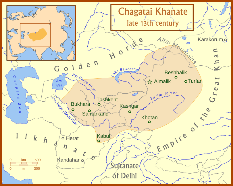 | ८११ × ६४६ (४६८ KB) | smartcommons>MapMaster | +river name, + colour adjustment |
फाइल के उपयोग
कौनों पन्ना नइखे जवन ए फाइल के इस्तेमाल करत होखे।
