ओरिजनल फाइल (३०१ × १७३ पिक्सेल, फाइल साइज: १५ KB, MIME टाइप: image/gif)

ई फाइल एगो सझियाई के भंडारघर से बा आ अउरी प्रोजेक्ट भी एकर इस्तेमाल कर सकत बाड़ें। एकर विवरण फाइल विवरण पन्ना नीचे देखावल गइल बा।

सारांश

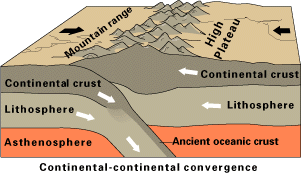
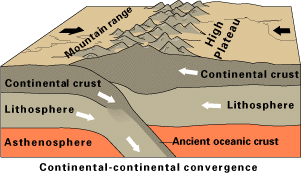
बिबरणContinental-continental convergence Fig21contcont.gif
English: w:Plate tectonics: convergence of two continental plates.
तारीख before २६ दिसंबर २००५
date QS:P,+2005-12-26T00:00:00Z/7,P1326,+2005-12-26T00:00:00Z/11
स्रोत
लेखक USGS
परमीशन
(एह फाइल के दुबारा इस्तेमाल)
Public domainPublic domainfalsefalse
Public domain
This image is in the public domain in the United States because it only contains materials that originally came from the United States Geological Survey, an agency of the United States Department of the Interior. For more information, see the official USGS copyright policy.

Bahasa Indonesia  català  čeština  Deutsch  eesti  English  español  français  galego  italiano  Nederlands  português  polski  sicilianu  suomi  Tiếng Việt  Türkçe  български  македонски  русский  മലയാളം  한국어  日本語  中文  中文(简体)  中文(繁體)  العربية  فارسی  +/−

Other versions

[संपादन करीं]

SVG

Bitmap

File:continental-continental convergence en.svg is a vector version of this file. It should be used in place of this GIF file when not inferior.

File:Continental-continental convergence Fig21contcont.gif → File:continental-continental convergence en.svg

For more information, see Help:SVG.

In other languages
Alemannisch  العربية  беларуская (тарашкевіца)  български  বাংলা  català  нохчийн  čeština  dansk  Deutsch  Ελληνικά  English  British English  Esperanto  español  eesti  euskara  فارسی  suomi  français  Frysk  galego  Alemannisch  עברית  हिन्दी  hrvatski  magyar  հայերեն  Bahasa Indonesia  Ido  italiano  日本語  ქართული  한국어  lietuvių  македонски  മലയാളം  Bahasa Melayu  မြန်မာဘာသာ  norsk bokmål  Plattdüütsch  Nederlands  norsk nynorsk  norsk  occitan  polski  prūsiskan  português  português do Brasil  română  русский  sicilianu  Scots  slovenčina  slovenščina  српски / srpski  svenska  தமிழ்  ไทย  Türkçe  татарча / tatarça  українська  vèneto  Tiếng Việt  中文  中文(中国大陆)  中文(简体)  中文(繁體)  中文(马来西亚)  中文(新加坡)  中文(臺灣)  +/−
New SVG image


Captions

Add a one-line explanation of what this file represents
Diagram of how fold mountains are formed.

Items portrayed in this file

depicts अंगरेजी

fold mountain अंगरेजी

copyright status अंगरेजी

public domain अंगरेजी

media type अंगरेजी

image/gif

checksum अंगरेजी

33ff2d7b7d25f8dae61751c8edbe21430955384c

determination method or standard अंगरेजी: SHA-1

data size अंगरेजी

१५,०९९ byte

height अंगरेजी

१७३ पिक्सेल

width अंगरेजी

३०१ पिक्सेल

फाइल के इतिहास

ओ समय ई फाइल कइसन लउके ई देखे खातिर कौनों तारीख/समय पर क्लिक करीं।

तारीख/समयचिप्पी रूपडाइमेंशनप्रयोगकर्ताटिप्पणी
वर्तमान२२:३४, ३१ दिसंबर २००६२२:३४, ३१ दिसंबर २००६ ले के संस्करण के चिप्पी रूप।३०१ × १७३ (१५ KB)smartcommons>Theklan{{Information |Description= Continental-continental plate convergence. |Source= English Wikipedia (Convergent boundary) |Date= |Author= USGS |Permission= PD-USGS |other_versions= }} Category:Plate tectonics {{USGS}}

कौनों पन्ना नइखे जवन ए फाइल के इस्तेमाल करत होखे।