चित्र:England and Wales population cartogram districts.svg

Size of this PNG preview of this SVG file: २२० × २५१ पिक्सेल. अउरी resolution: २१० × २४० पिक्सेल.
ओरिजनल फाइल (एसवीजी फाइल, नॉमिनली १,०२२ x १,१६६ पिक्सल, फाइल के आकार: ८०५ KB)
सारांश

| बिबरणEngland and Wales population cartogram districts.svg |
English: Population of districts. Their size shows their population, with some approximation, according to 2011 Census data. Each group of squares in the map key is 20 % of total number of districts.
Polski: Kartogram ludności Anglii i Walii. Liczba mieszkańców dystryktów. Wielkość dystryktów pokazuje liczbę jego mieszkańców, z pewnym przybliżeniem według danych z cenzusu z 2011. Każda grupa kwadratów w legendzie to 20 % liczby wszystkich dystryktów. |
| तारीख | |
| स्रोत | Own work based on: population density from Population Estimates for UK, England and Wales, Scotland and Northern Ireland - Office for National Statistics, 2015 |
| लेखक | PawełS |
| SVG genesis InfoField |


Software:
- ScapeToad (First grid 1 600; Diffusion grid size 1024; 8 iterations)
- QGIS: Cartogram Creator plugin 10 iterations
लाइसेंसिंग
I, the copyright holder of this work, hereby publish it under the following license:


ई फाइल Creative Commons Attribution-Share Alike 3.0 Unported लाइसेंस की तहत लाइसेंसी बा।
- आप फ्री बानी:
- साझा करे खातिर – रचना के नकल करे, बाँटे आ दुसरी जगह भेजे खातिर
- रीमिक्स करे खातिर – काम के अपनी हिसाब से बनावे खातिर
- नीचे दिहल कारणन की तहत:
- एट्रीब्यूशन – लाइसेंस के कड़ी दे के उचित श्रेय (क्रेडिट) दिहल जरूरी बा आ अगर कौनों बदलाव कइल गइल बा तब ओहू के बतावल जाए के चाहीं। आप ई काम कौनों उचित तरीका से क सकत बानी, बाकी ई न झलके के चाहीं की जेकरा लगे लाइसेंस बा ऊ राउर चाहे राउर काम के समर्थन करत बाटे या सही बतावत बा।
- शेयर अलाइक (share alike) – अगर आप एह सामग्री के आधार बना के कुछ रिमिक्स करत बानी, रूप बदलाव करत बानी, चाहे कुछ जोड़ के सामग्री के बढ़ावत बानी, आपके आपन योगदान ठीक एही या कंपेटिबल लाइसेंस जइसन कि ओरिजनल बाटे, के तहत होखे के चाहीं।
Captions
Add a one-line explanation of what this file represents
फाइल के इतिहास
ओ समय ई फाइल कइसन लउके ई देखे खातिर कौनों तारीख/समय पर क्लिक करीं।
| तारीख/समय | चिप्पी रूप | डाइमेंशन | प्रयोगकर्ता | टिप्पणी | |
|---|---|---|---|---|---|
| वर्तमान | २२:४४, १३ फरवरी २०१९ | 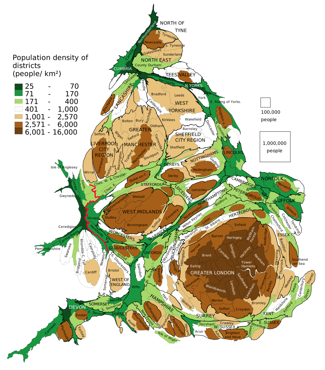 | १,०२२ × १,१६६ (८०५ KB) | smartcommons>PawełS | combined authorities |
फाइल के उपयोग
कौनों पन्ना नइखे जवन ए फाइल के इस्तेमाल करत होखे।
