चित्र:Europe and the Near East at 476 AD.png

ए नमूना के साइज: २२० × १५३ पिक्सेल. अउरी रिजोल्यूशन: ३२० × २२२ पिक्सेल | २,८३० × १,९६७ पिक्सेल.
ओरिजनल फाइल (२,८३० × १,९६७ पिक्सेल, फाइल साइज: १.५८ MB, MIME टाइप: image/png)

|
This historical map image could be re-created using vector graphics as a SVG file. This has several advantages; see Commons:Media for cleanup for more information. If a SVG form of this image is available, please upload it and afterwards replace this template with
{{vector version available|new image name}}.It is recommended to name the SVG file “Europe and the Near East at 476 AD.svg”—then the template Vector version available (or Vva) does not need the new image name parameter. |
सारांश
| बिबरणEurope and the Near East at 476 AD.png |
English: Political division in Europe, North Africa and Near East after the end of the Western Roman Empire in 476 AD. Romance area added since H. M. Glessegen (dir.), Handbuch der Romanische Sprachgeschichte, Berlin/New York, p. 544-555. Modified Gaëls / Picts / Britons (see discussion file).
Español: Mapa político de Europa, el Norte de África y Oriente Próximo tras el fin del Imperio Romano de Occidente en 476 d.C. Área románica añadida desde H. M. Glessegen (dir.), Handbuch der Romanische Sprachgeschichte, Berlín/Nueva York, p. 544-555. Gaëls / Pictos / Británicos modificados (ver archivo de discusión).
Français : L'Europe, l'Afrique du Nord et le Proche-Orient après la fin de l'Empire romain d'Occident en 476. Limites des langues romanes ajoutées d'après H. M. Glessegen (dir.), Handbuch der Romanische Sprachgeschichte, Berlin/New York, p. 544-555. Modifié les Gaëls / Pictes / Bretons d'après la page de discussion. |
| तारीख | |
| स्रोत | Putzger Historischer Weltatlas, Cornelsen, Berlin 1992 ISBN 3-464-00176-8, pp. 34-35 (maps by R. Hachmann). |
| लेखक | Guriezous |
| परमीशन (एह फाइल के दुबारा इस्तेमाल) |
आपन रचना |
| Other versions |

.png)

लाइसेंसिंग
I, the copyright holder of this work, hereby publish it under the following license:


This file is licensed under the Creative Commons Attribution-Share Alike 4.0 International license.
- आप फ्री बानी:
- साझा करे खातिर – रचना के नकल करे, बाँटे आ दुसरी जगह भेजे खातिर
- रीमिक्स करे खातिर – काम के अपनी हिसाब से बनावे खातिर
- नीचे दिहल कारणन की तहत:
- एट्रीब्यूशन – लाइसेंस के कड़ी दे के उचित श्रेय (क्रेडिट) दिहल जरूरी बा आ अगर कौनों बदलाव कइल गइल बा तब ओहू के बतावल जाए के चाहीं। आप ई काम कौनों उचित तरीका से क सकत बानी, बाकी ई न झलके के चाहीं की जेकरा लगे लाइसेंस बा ऊ राउर चाहे राउर काम के समर्थन करत बाटे या सही बतावत बा।
- शेयर अलाइक (share alike) – अगर आप एह सामग्री के आधार बना के कुछ रिमिक्स करत बानी, रूप बदलाव करत बानी, चाहे कुछ जोड़ के सामग्री के बढ़ावत बानी, आपके आपन योगदान ठीक एही या कंपेटिबल लाइसेंस जइसन कि ओरिजनल बाटे, के तहत होखे के चाहीं।
Captions
Add a one-line explanation of what this file represents
A political map of Europe, North Africa and the Near East after the end of the Western Roman Empire in 476 CE.
Политическая карта Европы, Северной Африки и Ближнего Востока после падения Западной Римской империи в 476 году
फाइल के इतिहास
ओ समय ई फाइल कइसन लउके ई देखे खातिर कौनों तारीख/समय पर क्लिक करीं।
| तारीख/समय | चिप्पी रूप | डाइमेंशन | प्रयोगकर्ता | टिप्पणी | |
|---|---|---|---|---|---|
| वर्तमान | ०७:०१, ८ जनवरी २०२५ | 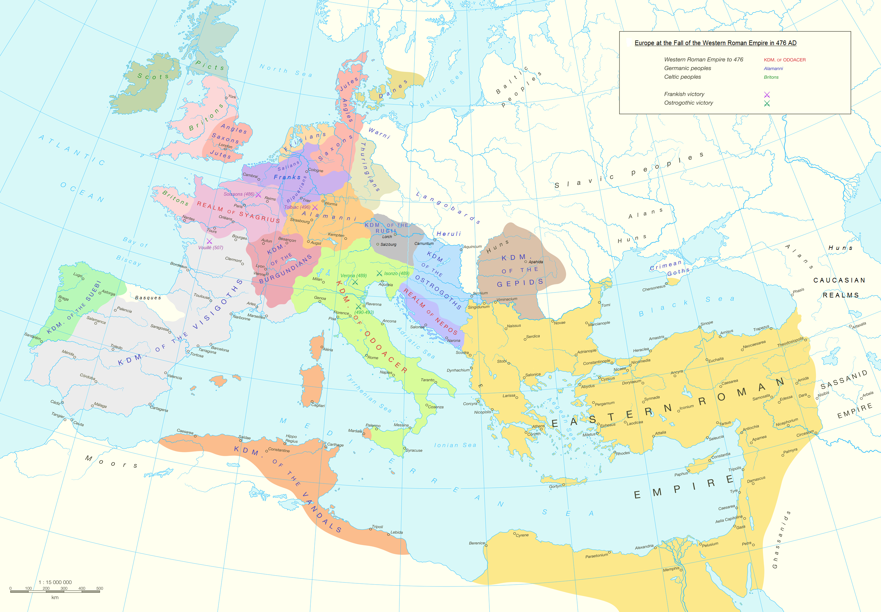 | २,८३० × १,९६७ (१.५८ MB) | smartcommons>GPinkerton | Reverted to version as of 03:35, 9 January 2022 (UTC) COM:CROP |
फाइल के उपयोग
कौनों पन्ना नइखे जवन ए फाइल के इस्तेमाल करत होखे।
