चित्र:Famine en URSS 1933.jpg

ओरिजनल फाइल (६४९ × ९०५ पिक्सेल, फाइल साइज: ६१० KB, MIME टाइप: image/jpeg)
सारांश
| बिबरणFamine en URSS 1933.jpg |
English: Famine in USSR, 1933. Areas of most disastrous famine marked with black.
Explanation of symbols on the map: A - grain-consuming regions, B - grain-producing regions. C - former land of Don, Kuban and Terek cossacks, C1 - former land of Ural and Orenburg cossacks. 1. Kola Peninsula, 2. Northern region, 3. Karelia, 4. Komi, 5. Leningrad Oblast, 6. Ivanovo Oblast, 7. Moscow Oblast, 8. Nizhny Novgorod region, 9. Western Oblast. 10. Byelorussia, 11. Central Black Earth Region, 12. Ukraine, 13. Central Volga region, 14. Tataria, 15. Bashkiria, 16. Ural region, 17. Lower Volga region, 18. North Caucasus Krai, 19. Georgia, 20. Azerbaijan, 21. Armenia.Русский: Объяснение обозначений на карте: A - районы потребляющей полосы, B - районы производящей полосы. C - бывшая территория донских, кубанских и терских казаков, C1 - бывшая территория уральских и оренбургских казаков.
1. Кольский полуостров, 2. Северный край, 3. Карелия, 4. Область Коми, 5. Ленинградская (Петербургская) область, 6. Ивановская промышленная область, 7. Московская область, 8. Нижегородский край, 9. Западная область. 10. Белоруссия, 11. Центрально-Чернозёмная область, 12. Украина, 13. Средне-Волжский край, 14. Татария, 15. Башкирия, 16. Уральская область, 17. Нижневолжский край, 18. Северо-Кавказский край, 19. Грузия, 20. Азербайджан, 21. Армения. |
|||||
| तारीख | ||||||
| स्रोत |
1. A. Markoff "Famine in USSR" [1] 2. приложение к N 4-5 эмигрантского журнала "За рулем", август-сентябрь 1933 года. Перепечатка из Русского экономического бюллетеня, 9. [2] |
|||||
| लेखक | неизв. | |||||
| परमीशन (एह फाइल के दुबारा इस्तेमाल) |
|
|||||
| Other versions |
|
|||||


Captions
फाइल के इतिहास
ओ समय ई फाइल कइसन लउके ई देखे खातिर कौनों तारीख/समय पर क्लिक करीं।
| तारीख/समय | चिप्पी रूप | डाइमेंशन | प्रयोगकर्ता | टिप्पणी | |
|---|---|---|---|---|---|
| वर्तमान | १६:४९, २ मार्च २०१४ | 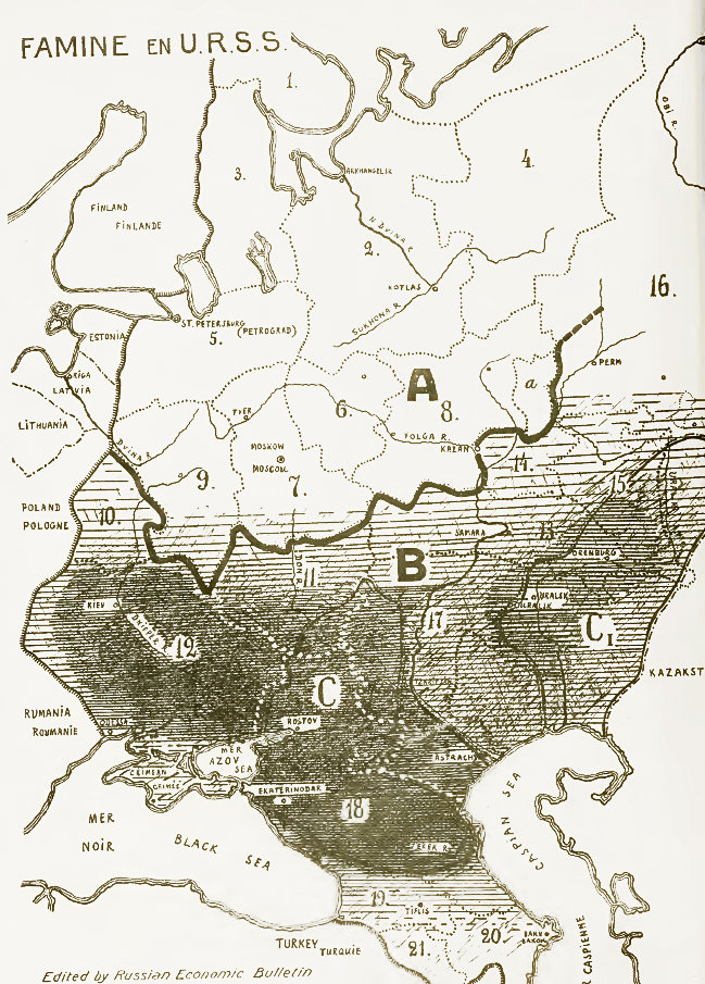 | ६४९ × ९०५ (६१० KB) | smartcommons>Soerfm | Color, contrast |
फाइल के उपयोग
कौनों पन्ना नइखे जवन ए फाइल के इस्तेमाल करत होखे।
