ओरिजनल फाइल (१,२३२ × ९५८ पिक्सेल, फाइल साइज: ३२३ KB, MIME टाइप: image/jpeg)

ई फाइल एगो सझियाई के भंडारघर से बा आ अउरी प्रोजेक्ट भी एकर इस्तेमाल कर सकत बाड़ें। एकर विवरण फाइल विवरण पन्ना नीचे देखावल गइल बा।

बिबरणIndia1837to1857.jpg
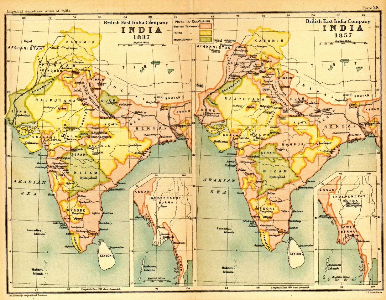
English: Image of map of India under the British East India Company, comparing 1837 with 1857
तारीख
स्रोत Imperial Gazetteer of India, Secretary of State for India in Council, OUP, 1907. Scanned from personal copy Fowler&fowler, 2007
लेखक Edinburgh Geographical Institute.
परमीशन
(एह फाइल के दुबारा इस्तेमाल)
Public domainPublic domainfalsefalse
Public domain
This work is in the public domain in the United States because it was published (or registered with the U.S. Copyright Office) before January 1, 1931.

Public domain works must be out of copyright in both the United States and in the source country of the work in order to be hosted on the Commons. If the work is not a U.S. work, the file must have an additional copyright tag indicating the copyright status in the source country.
Note: This tag should not be used for sound recordings.PD-1923Public domain in the United States//commons.wikimedia.org/wiki/File:India1837to1857.jpg
Public domainPublic domainfalsefalse
Public domain
This work created by the United Kingdom Government is in the public domain.

This is because it is one of the following:

  1. It is a photograph taken prior to 1 June 1957; or
  2. It was published prior to 1976; or
  3. It is an artistic work other than a photograph or engraving (e.g. a painting) which was created prior to 1976.

HMSO has declared that the expiry of Crown Copyrights applies worldwide (ref: HMSO Email Reply)
More information.

See also Copyright and Crown copyright artistic works.

Deutsch  English  Español  français  Bahasa Indonesia  italiano  Nederlands  polski  português  sicilianu  slovenščina  suomi  Türkçe  македонски  русский  українська  മലയാളം  한국어  日本語  Bahaso Jambi  简体中文  繁體中文  العربية  +/−

Captions

Add a one-line explanation of what this file represents
India in 1837 and 1857, showing East India Company-governed territories in pink

Items portrayed in this file

depicts अंगरेजी

copyright status अंगरेजी

public domain अंगरेजी

inception अंगरेजी

1907

data size अंगरेजी

३३०,४५८ byte

height अंगरेजी

९५८ पिक्सेल

width अंगरेजी

१,२३२ पिक्सेल

media type अंगरेजी

image/jpeg

checksum अंगरेजी

18b3df47c536a4d4db197d1de4dd4e2d5865cb62

determination method or standard अंगरेजी: SHA-1

फाइल के इतिहास

ओ समय ई फाइल कइसन लउके ई देखे खातिर कौनों तारीख/समय पर क्लिक करीं।

तारीख/समयचिप्पी रूपडाइमेंशनप्रयोगकर्ताटिप्पणी
वर्तमान२१:३७, ३० अप्रैल २०१३२१:३७, ३० अप्रैल २०१३ ले के संस्करण के चिप्पी रूप।१,२३२ × ९५८ (३२३ KB)smartcommons>Gz deleted{{Information |Description=Indian map |Source=en wiki |Date=unknown |Author=unknown |Permission={{GFDL-user-w|||User:Fowler&fowler}} |other_versions= }}

कौनों पन्ना नइखे जवन ए फाइल के इस्तेमाल करत होखे।