चित्र:India and South Asia Köppen climate map with legend.jpg

ओरिजनल फाइल (५४५ × ५३७ पिक्सेल, फाइल साइज: ६० KB, MIME टाइप: image/jpeg)
सारांश
| बिबरणIndia and South Asia Köppen climate map with legend.jpg |
English: South Asia- Köppen-Geiger climate classification map is based on native vegetation, temperature, precipitation and their seasonality.
|
| तारीख | |
| स्रोत |
|
| लेखक |
File:World Köppen Map.png: Original file by Peel, M. C., Finlayson, B. L., and McMahon, T. A. (University of Melbourne). Derivative work: Modifications by user Br-Sc-94, (User talk). Cropping & addition of map legend-color box-to summary info by 2know4power, (User talk). |
Legend
 |
This is a retouched picture, which means that it has been digitally altered from its original version. Modifications: Climate change in 2009. The original can be viewed here: World Köppen Map.png:  . Modifications made by Br-Sc-94. . Modifications made by Br-Sc-94.
|
लाइसेंसिंग


- आप फ्री बानी:
- साझा करे खातिर – रचना के नकल करे, बाँटे आ दुसरी जगह भेजे खातिर
- रीमिक्स करे खातिर – काम के अपनी हिसाब से बनावे खातिर
- नीचे दिहल कारणन की तहत:
- एट्रीब्यूशन – लाइसेंस के कड़ी दे के उचित श्रेय (क्रेडिट) दिहल जरूरी बा आ अगर कौनों बदलाव कइल गइल बा तब ओहू के बतावल जाए के चाहीं। आप ई काम कौनों उचित तरीका से क सकत बानी, बाकी ई न झलके के चाहीं की जेकरा लगे लाइसेंस बा ऊ राउर चाहे राउर काम के समर्थन करत बाटे या सही बतावत बा।
- शेयर अलाइक (share alike) – अगर आप एह सामग्री के आधार बना के कुछ रिमिक्स करत बानी, रूप बदलाव करत बानी, चाहे कुछ जोड़ के सामग्री के बढ़ावत बानी, आपके आपन योगदान ठीक एही या कंपेटिबल लाइसेंस जइसन कि ओरिजनल बाटे, के तहत होखे के चाहीं।
Explanatory notes
This map- File-India_and_South_Asia_Köppen_climate_map_with_legend.jpg is cropped from source map File:Köppen World Map (retouched version).png.[1] Some explanations are given below.
.png)
Lack of recording stations: Alps, Temperate zone in South India
Extent of Temperate climate markings ( “C” zone) in South India
In map File:Köppen World Map (retouched version).png-The Temperate climate markings ( “C” zone) are larger in Tropical South India, around Kodaikanal which is on the eastern side of Western Ghats mountains in Tamil Nadu state, at a higher elevation (~2300m). And also the temperate climate markings extend further South than expected. This is due to recordings from temperature station at Kodaikanal & lack of recording stations from nearby lowland areas, so markings could not be corrected due to lack of data.[1]
Extent of Alps in Europe marked as E zone; (Himalayas-high mountains- not marked as “E” zone)
In map File:Köppen World Map (retouched version).png-Alps high mountains are marked as “E” zone in this map. But “E” zone markings in the map for the Alps- high mountains do not cover the extent expected, because of lack of recording stations.[1] In this map, Himalayas -high mountains- are not marked as “E” zone.
Another map from a different source, shows no "C" zone in South India, Himalayas high mountains marked as "E" zone
Another map with reliable source is in references list given below. This map is based on data sets from the Climatic Research Unit (CRU) of the University of East Anglia and the Global Precipitation Climatology Centre (GPCC) at the German Weather Service.This is a digital Köppen–Geiger world map[2] on climate classification for the second half of the 20th century.
World Map of the Köppen-Geiger climate classification updated
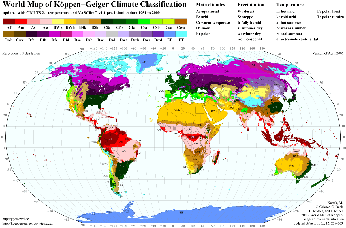
This map[2] shows no temperate "C" zone in tropical South India & Himalayas high mountains are marked as polar "E" zone.
References
- ↑ a b c Peel, M. C. and Finlayson, B. L. and McMahon, T. A. (2007). "Updated world map of the Köppen–Geiger climate classification". Hydrol. Earth Syst. Sci. 11: 1633–1644. DOI:10.5194/hess-11-1633-2007. ISSN 1027-5606. (direct: Final Revised Paper).
- ↑ a b c d Kottek, M., J. Grieser, C. Beck, B. Rudolf, and F. Rubel (2006). "World Map of the Köppen–Geiger climate classification updated". Meteorol. Z. 15 (3): 259–263. DOI:10.1127/0941-2948/2006/0130. Retrieved on 2013-06-01.(direct- Kottek 2006 Paper)
Related maps
User Jeroenvrp made for these continents and areas a cropped and resized version:
- Africa Köppen Map.png
- Asia Köppen Map.png
- Australia-Oceania Köppen Map.png
- Europe Köppen Map.png
- North America Köppen Map.png
- Russia Köppen Map.png
- South America Köppen Map.png
- West Asia Köppen Map.png.


User LordToran made from the same data these maps:
- Klimagürtel-der-erde-eisklima.png
- Klimagürtel-der-erde-gemäßigte-zone.png
- Klimagürtel-der-erde-polargebiete.png
- Klimagürtel-der-erde-subtropen.png
- Klimagürtel-der-erde-tropen.png
- Klimagürtel-der-erde-tundra.png
- Klimagürtel-der-erde-warmgemäßigte-zone.png
- Klimagürtel-der-erde.png
- Klimagürtel-der-erde.svg
- Klimate-humidität.png
- Köppen-geiger-hessd-2007.svg
- Köppen-vereinfacht.svg
- Trockenklimate.png


Captions
फाइल के इतिहास
ओ समय ई फाइल कइसन लउके ई देखे खातिर कौनों तारीख/समय पर क्लिक करीं।
| तारीख/समय | चिप्पी रूप | डाइमेंशन | प्रयोगकर्ता | टिप्पणी | |
|---|---|---|---|---|---|
| वर्तमान | ०८:५८, २० नवंबर २०१५ | 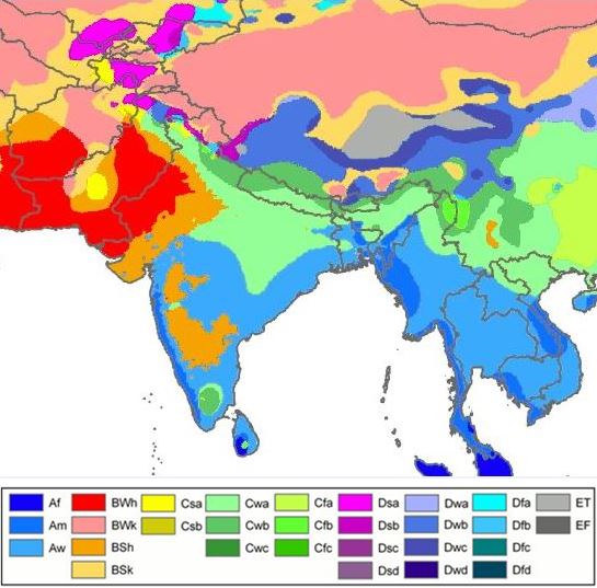 | ५४५ × ५३७ (६० KB) | smartcommons>2know4power | User created page with UploadWizard |
फाइल के उपयोग
कौनों पन्ना नइखे जवन ए फाइल के इस्तेमाल करत होखे।
