चित्र:Kentucky Bend map.png

ए नमूना के साइज: २२० × २२० पिक्सेल. अउरी रिजोल्यूशन: २४० × २४० पिक्सेल | ७२० × ७२० पिक्सेल.
ओरिजनल फाइल (७२० × ७२० पिक्सेल, फाइल साइज: ३१ KB, MIME टाइप: image/png)

सारांश
| बिबरणKentucky Bend map.png | |
| तारीख | |
| स्रोत | self; based on US Census TIGER generated map image |
| लेखक | Jim Efaw (self) |
| परमीशन (एह फाइल के दुबारा इस्तेमाल) |
CC-By-SA for overlay; original map is public domain US government work |
| Other versions | Image:Kentucky Bend.png |


English: This is a map of the Kentucky Bend, the southwest corner of Fulton County, Kentucky that was separated from the rest of the state by the change in the Mississippi River from the New Madrid earthquakes. Based on United States Census TIGER Map output. Color and state abbreviation overlays created using The Gimp; optimized using pngnq and PNGOUT. 720×720, 32 color 8-bit palette.
लाइसेंसिंग
Jim Efaw, author of this work, the copyright holder of this work, hereby publishes it under the following license:


This file is licensed under the Creative Commons Attribution-Share Alike 2.5 Generic, 2.0 Generic and 1.0 Generic license.
एट्रीब्यूशन:
Jim Efaw, author of this work
- आप फ्री बानी:
- साझा करे खातिर – रचना के नकल करे, बाँटे आ दुसरी जगह भेजे खातिर
- रीमिक्स करे खातिर – काम के अपनी हिसाब से बनावे खातिर
- नीचे दिहल कारणन की तहत:
- एट्रीब्यूशन – लाइसेंस के कड़ी दे के उचित श्रेय (क्रेडिट) दिहल जरूरी बा आ अगर कौनों बदलाव कइल गइल बा तब ओहू के बतावल जाए के चाहीं। आप ई काम कौनों उचित तरीका से क सकत बानी, बाकी ई न झलके के चाहीं की जेकरा लगे लाइसेंस बा ऊ राउर चाहे राउर काम के समर्थन करत बाटे या सही बतावत बा।
- शेयर अलाइक (share alike) – अगर आप एह सामग्री के आधार बना के कुछ रिमिक्स करत बानी, रूप बदलाव करत बानी, चाहे कुछ जोड़ के सामग्री के बढ़ावत बानी, आपके आपन योगदान ठीक एही या कंपेटिबल लाइसेंस जइसन कि ओरिजनल बाटे, के तहत होखे के चाहीं।
Captions
Add a one-line explanation of what this file represents
फाइल के इतिहास
ओ समय ई फाइल कइसन लउके ई देखे खातिर कौनों तारीख/समय पर क्लिक करीं।
| तारीख/समय | चिप्पी रूप | डाइमेंशन | प्रयोगकर्ता | टिप्पणी | |
|---|---|---|---|---|---|
| वर्तमान | ११:०५, १४ जनवरी २००७ | 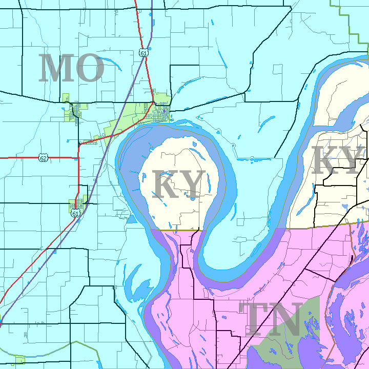 | ७२० × ७२० (३१ KB) | smartcommons>Closeapple | {{Information |Description=Map of Kentucky Bend w:exclave between Missouri and Tennessee, USA. |Source=self; based on [http://tiger.census.gov/cgi-bin/mapper/map.gif?&lat=39.74099&lon=-89.07248&ht=6.000&wid=5.000&on=CITIES&on=shorelin&on=states&on |
फाइल के उपयोग
कौनों पन्ना नइखे जवन ए फाइल के इस्तेमाल करत होखे।
