चित्र:Map Iran 1900-en.png

ए नमूना के साइज: २२० × १८३ पिक्सेल. अउरी रिजोल्यूशन: २८९ × २४० पिक्सेल | १,०९६ × ९११ पिक्सेल.
ओरिजनल फाइल (१,०९६ × ९११ पिक्सेल, फाइल साइज: ३५२ KB, MIME टाइप: image/png)


|
This historical map image could be re-created using vector graphics as a SVG file. This has several advantages; see Commons:Media for cleanup for more information. If a SVG form of this image is available, please upload it and afterwards replace this template with
{{vector version available|new image name}}.It is recommended to name the SVG file “Map Iran 1900-en.svg”—then the template Vector version available (or Vva) does not need the new image name parameter. |
सारांश
| बिबरणMap Iran 1900-en.png |
English: Iran circa 1900. Inspired by the Historical Atlas by Georges Duby, p. 211, map C, this map was made by Fabienkhan on 25 September 2006 using Inkscape and GIMP.
Français : L’Iran vers 1900. Inspirée par l’Atlas historique de Georges Duby, p. 211, carte C, cette carte a été conçue par Fabienkhan le 25 septembre 2006 à l’aide d’Inkscape et de GIMP. |
| तारीख | २४ सितंबर २००६ (original upload date) |
| स्रोत | आपन रचना |
| लेखक | Fabienkhan |
| Other versions | See also the French version: File:Map_Iran_1900-fr.png |

लाइसेंसिंग
I, the copyright holder of this work, hereby publish it under the following license:


This file is licensed under the Creative Commons Attribution-Share Alike 2.5 Generic, 2.0 Generic and 1.0 Generic license.
- आप फ्री बानी:
- साझा करे खातिर – रचना के नकल करे, बाँटे आ दुसरी जगह भेजे खातिर
- रीमिक्स करे खातिर – काम के अपनी हिसाब से बनावे खातिर
- नीचे दिहल कारणन की तहत:
- एट्रीब्यूशन – लाइसेंस के कड़ी दे के उचित श्रेय (क्रेडिट) दिहल जरूरी बा आ अगर कौनों बदलाव कइल गइल बा तब ओहू के बतावल जाए के चाहीं। आप ई काम कौनों उचित तरीका से क सकत बानी, बाकी ई न झलके के चाहीं की जेकरा लगे लाइसेंस बा ऊ राउर चाहे राउर काम के समर्थन करत बाटे या सही बतावत बा।
- शेयर अलाइक (share alike) – अगर आप एह सामग्री के आधार बना के कुछ रिमिक्स करत बानी, रूप बदलाव करत बानी, चाहे कुछ जोड़ के सामग्री के बढ़ावत बानी, आपके आपन योगदान ठीक एही या कंपेटिबल लाइसेंस जइसन कि ओरिजनल बाटे, के तहत होखे के चाहीं।

Note:
 Inspired by the Historical Atlas by Georges Duby, p. 211, map C, this map was made by Fabienkhan on 25 September 2006 with Inkscape and GIMP.
 Inspiré par l’Atlas historique de Georges Duby, p. 211, carte C, cette carte a été conçue par Fabienkhan le 25 septembre 2006 à l’aide d’Inkscape et de GIMP.
Description:
L’Iran vers 1900
Iran circa 1900
Captions
Add a one-line explanation of what this file represents
फाइल के इतिहास
ओ समय ई फाइल कइसन लउके ई देखे खातिर कौनों तारीख/समय पर क्लिक करीं।
| तारीख/समय | चिप्पी रूप | डाइमेंशन | प्रयोगकर्ता | टिप्पणी | |
|---|---|---|---|---|---|
| वर्तमान | २३:१०, ६ अगस्त २०१७ | 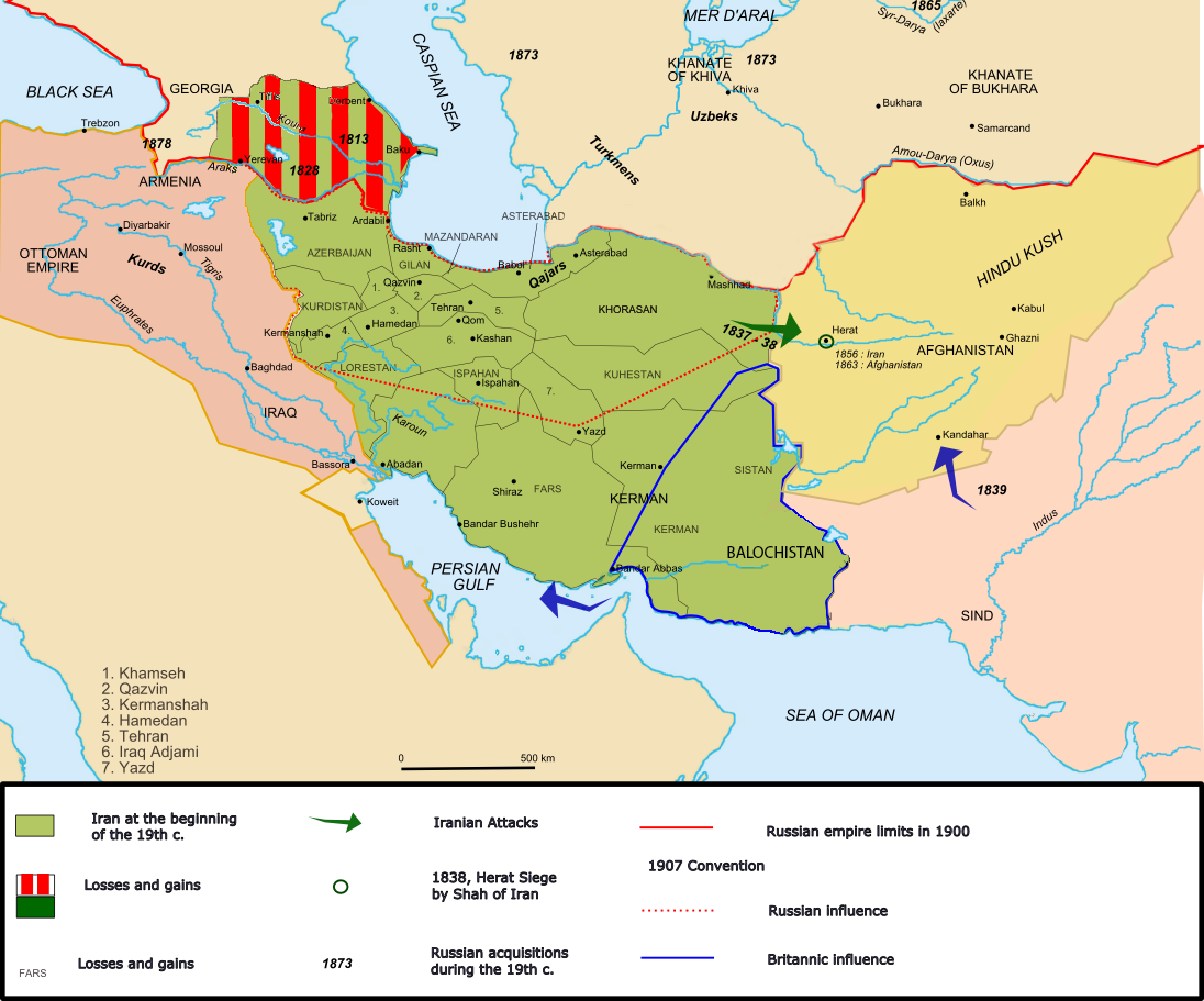 | १,०९६ × ९११ (३५२ KB) | smartcommons>Oganesson007 | Added Kingdom of Kartli-Kakheti, deleted modern day Turkmenistan, which was never under Qajar's control. |
फाइल के उपयोग
कौनों पन्ना नइखे जवन ए फाइल के इस्तेमाल करत होखे।
