चित्र:Map of the Periplus of the Erythraean Sea.jpg

ए नमूना के साइज: २२० × १२१ पिक्सेल. अउरी रिजोल्यूशन: ३२० × १७५ पिक्सेल | ३,५०७ × १,९२१ पिक्सेल.
ओरिजनल फाइल (३,५०७ × १,९२१ पिक्सेल, फाइल साइज: १.५८ MB, MIME टाइप: image/jpeg)
Note that the vector version contains the same information but parts of it have a different layout
सारांश
| बिबरणMap of the Periplus of the Erythraean Sea.jpg | Locations, names and routes of the Periplus of the Erythraean Sea (1st century CE). | |||
| तारीख | ||||
| स्रोत | self-made, background topographical map from Wikipedia Commons Image:Topographic30deg N0E60.png | |||
| लेखक | PHGCOM | |||
| Other versions |
|


लाइसेंसिंग
PHGCOM, the copyright holder of this work, hereby publishes it under the following licenses:

|
जीएनयू फ्री डाकुमेंटेशन लाइसेंस, वर्जन 1.2 या फिर कौनो भी बाद के प्रकाशित फ्री साफ्टवेयर फाउंडेशन लाइसेंस के शर्त के तहत, एह डाकुमेंट के नकल करे, बितरण करे आ/भा बदलाव करे के परमीशन दिहल गइल बा; एह में इनवैरिएंट खंड सभ नइखे शामिल, मुखपृष्ट के पाठ नइखे शामिल, आ बैक-कभर के पाठ नइखे शामिल। लाइसेंस के एगो प्रति जीएनयू फ्री डाकुमेंटेशन लाइसेंस नाँव के खंड में दिहल गइल बा।http://www.gnu.org/copyleft/fdl.htmlGFDLGNU Free Documentation Licensetruetrue |


This file is licensed under the Creative Commons Attribution-Share Alike 4.0 International, 3.0 Unported, 2.5 Generic, 2.0 Generic and 1.0 Generic license.
एट्रीब्यूशन:
PHGCOM
- आप फ्री बानी:
- साझा करे खातिर – रचना के नकल करे, बाँटे आ दुसरी जगह भेजे खातिर
- रीमिक्स करे खातिर – काम के अपनी हिसाब से बनावे खातिर
- नीचे दिहल कारणन की तहत:
- एट्रीब्यूशन – लाइसेंस के कड़ी दे के उचित श्रेय (क्रेडिट) दिहल जरूरी बा आ अगर कौनों बदलाव कइल गइल बा तब ओहू के बतावल जाए के चाहीं। आप ई काम कौनों उचित तरीका से क सकत बानी, बाकी ई न झलके के चाहीं की जेकरा लगे लाइसेंस बा ऊ राउर चाहे राउर काम के समर्थन करत बाटे या सही बतावत बा।
- शेयर अलाइक (share alike) – अगर आप एह सामग्री के आधार बना के कुछ रिमिक्स करत बानी, रूप बदलाव करत बानी, चाहे कुछ जोड़ के सामग्री के बढ़ावत बानी, आपके आपन योगदान ठीक एही या कंपेटिबल लाइसेंस जइसन कि ओरिजनल बाटे, के तहत होखे के चाहीं।
रउआँ अपनी जरूरत के लाइसेंस बीछ सकत बानीं।
Original upload log
| date/time | username | resolution | size | edit summary |
|---|---|---|---|---|
| 2007-07-17T19:02:29Z | User:PHGCOM | 3507×1921 | 1.23Gb | Better map |
| 2007-07-10T21:10:51Z | User:PHGCOM | 3511×1924 | 1.24Gb | Better map |
| 2007-07-09T20:23:57Z | User:PHGCOM | 6591×3601 | 3.37Gb | Better map |
| 2007-07-01T19:57:31Z | User:PHGCOM | 3505×1913 | 1.21Gb | Better map. |
| 2007-07-01T13:15:47Z | User:PHGCOM | 3496×1918 | 1.19Gb | {{Information |Description=Locations, names and routes of the Periplus of the Erythraean Sea (1st century CE). |Source=self-made, background topographical map from Wikipedia Commons [[:Image:Topographic30deg N0E60.png]] |Date=2007 |Author= [[User:PHGCOM| |
Captions
Add a one-line explanation of what this file represents
Ubicaciones, nombres y rutas del Periplo del Mar Eritreo.
फाइल के इतिहास
ओ समय ई फाइल कइसन लउके ई देखे खातिर कौनों तारीख/समय पर क्लिक करीं।
| तारीख/समय | चिप्पी रूप | डाइमेंशन | प्रयोगकर्ता | टिप्पणी | |
|---|---|---|---|---|---|
| वर्तमान | १६:३५, ४ अगस्त २०१७ | 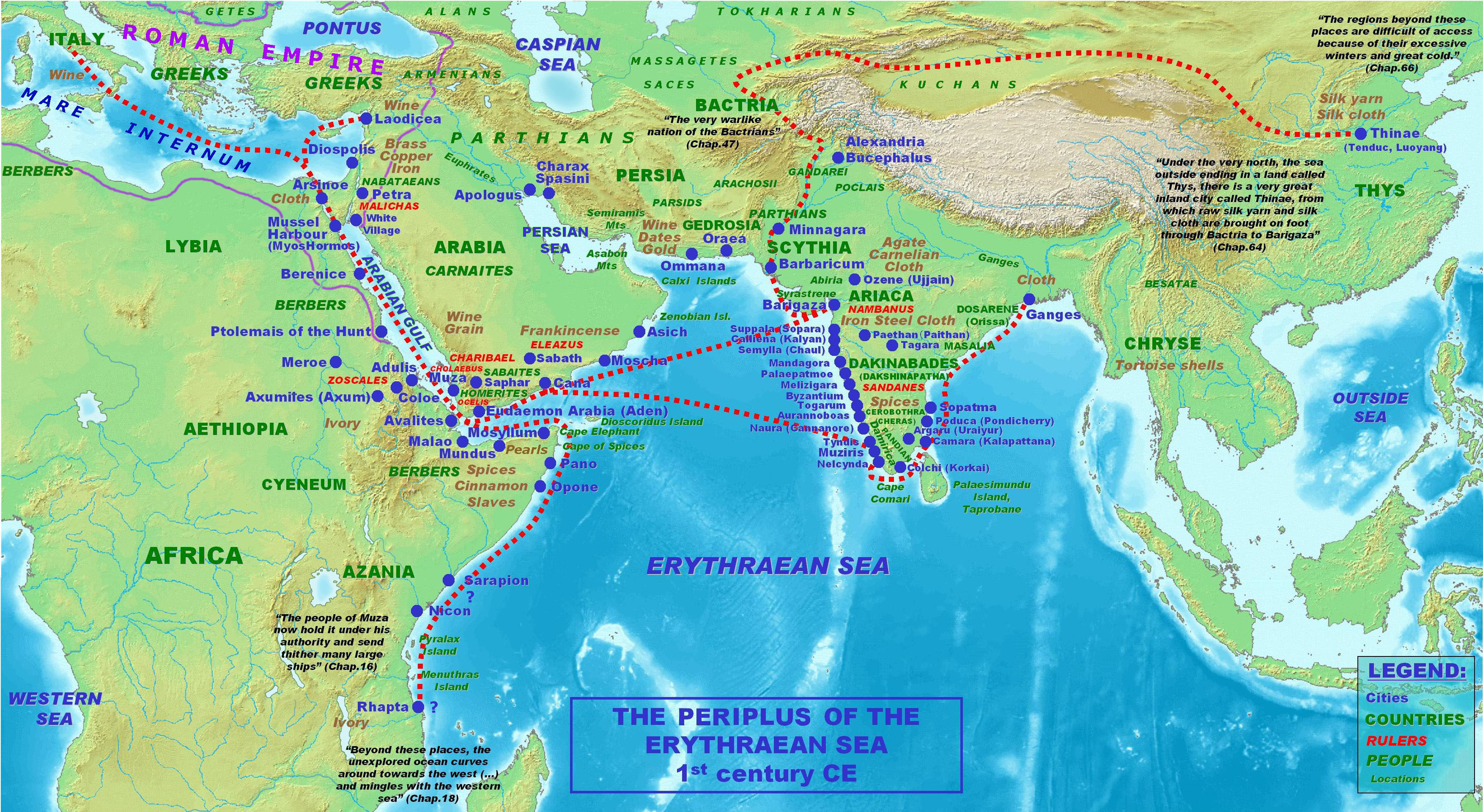 | ३,५०७ × १,९२१ (१.५८ MB) | smartcommons>Julieta39 | Maeotis lake = Azov sea ; Nicon, Sarapion, Rhapta = uncertain places |
फाइल के उपयोग
कौनों पन्ना नइखे जवन ए फाइल के इस्तेमाल करत होखे।
