Jump to content

चित्र:Maurya Empire, c.250 BCE 2.png

भोजपुरीपिडिया से

ओरिजनल फाइल (१,२०० × १,१२१ पिक्सेल, फाइल साइज: २.२६ MB, MIME टाइप: image/png)

ई फाइल एगो सझियाई के भंडारघर से बा आ अउरी प्रोजेक्ट भी एकर इस्तेमाल कर सकत बाड़ें। एकर विवरण फाइल विवरण पन्ना नीचे देखावल गइल बा।

सारांश

बिबरणMaurya Empire, c.250 BCE 2.png
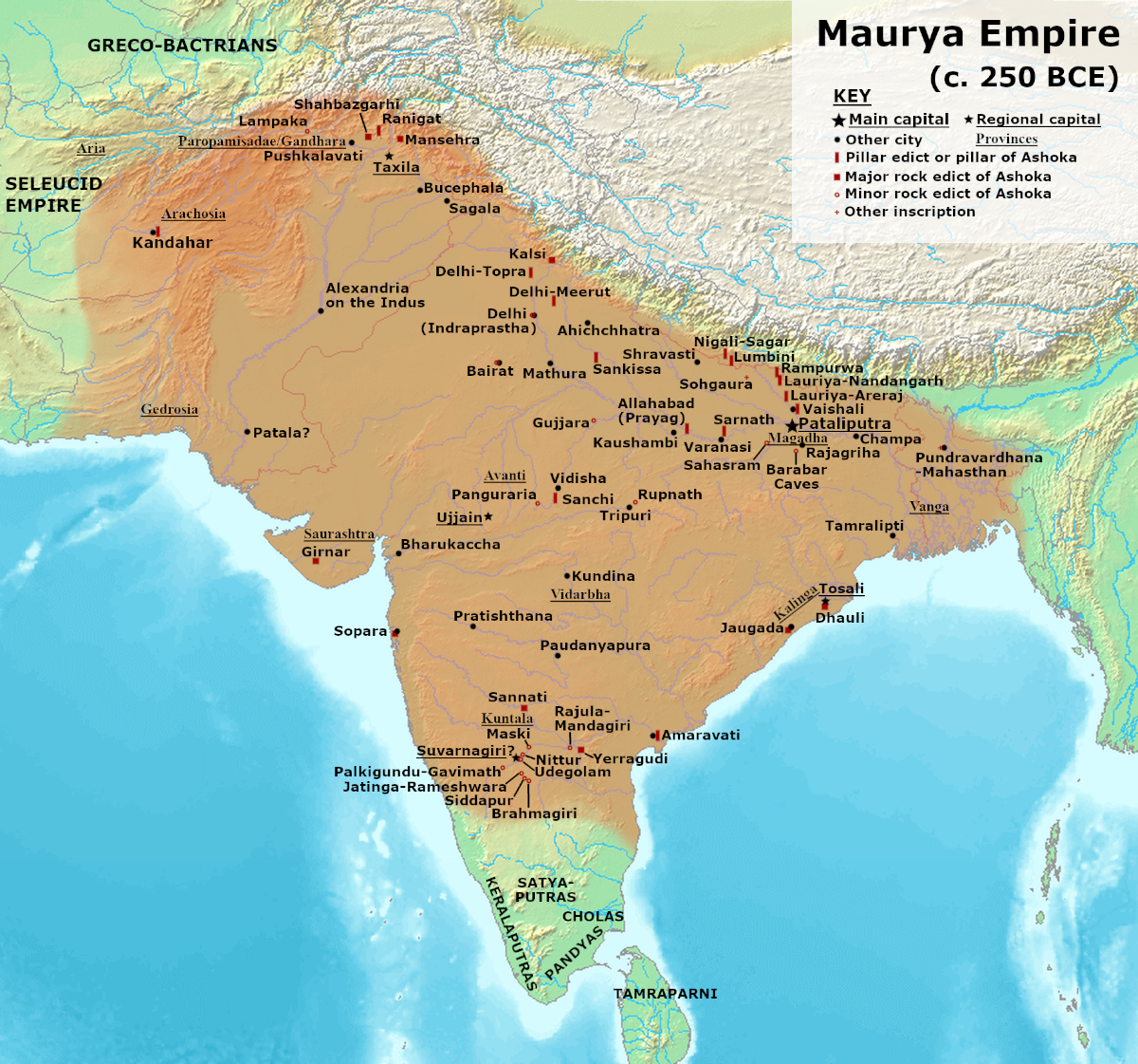
English: Note: This was the traditional map of the Maurya Empire at it's maximum extent, as a solid-mass of Maurya-controlled territory. Historians are now arguing that the Maurya Empire did not include large parts of India, which were controlled by autonomous tribes. For such a map, see File:Maurya Empire, c.250 BCE.png.
Alternative map of Maurya Empire

Boundaries are based on Charles Joppen Historical Atlas of India (1907), see File:India_in_250_B._C.jpg.

Other Sources:

Other sources:

  • Grainger, John D. (1990, 2014). Seleukos Nikator: Constructing a Hellenistic Kingdom. Routledge.
  • Keay, John (2000). India, a History. New York: Harper Collins Publishers.
  • Kulke, H.; Rothermund, D. (2004). A History of India, 4th, Routledge.
  • Puri, Baji Nath (1996). Buddhism in Central Asia. Delhi: Motilal Banarsidass.
  • Raychaudhuri, H. C.; Mukherjee, B. N. (1996). Political History of Ancient India: From the Accession of Parikshit to the Extinction of the Gupta Dynasty. Oxford University Press.
  • Stein, Burton (1998). A History of India (1st ed.), Oxford: Wiley-Blackwell.

Notes:

  • Sri Lanka and the southernmost parts of India (modern Tamil Nadu and Kerala) remained independent, despite the diplomacy and cultural influence of their larger neighbor to the north (Schwartzberg 1992, p. 18; Kulke & Rothermund 2004, p. 68).
  • The account of Strabo indicates that the western-most territory of the empire extended from the southeastern Hindu Kush, through the region of Kandahar, to coastal Baluchistan south of that (Raychaudhuri & Mukherjee 1996, p. 594).
  • The claim that Aria/Herat was one of the provinces (alongside Arachosia, Gedrosia, and Paropamisadae) ceded by Seleucus to Chandragupta Maurya is often repeated, but Aria (modern Herat) "has been wrongly included in the list of ceded satrapies by some scholars [...] on the basis of wrong assessments of the passage of Strabo [...] and a statement by Pliny." (Raychaudhuri & Mukherjee 1996, p. 594). Seleucus "must [...] have held Aria", and furthermore, his "son Antiochos was active there fifteen years later." (Grainger 2014, p. 109).
  • "The region of Aria is definitely known to have been Seleucid under Seleucus I and Antiochus I as it definitely was after Antiochus III's great campaign in the east against the Parthians and Bactrians. [...] There is no evidence whatever that it did not remain Seleucid, like Drangiana, with which it is linked by easy routes." -Susan M. Sherwin-White and Amélie Kuhrt (1993) From Samarkhand to Sardis: A New Approach to the Seleucid Empire, University of California Press, pp.79-80.
  • It is recorded that Drangiana province continued to be in the Seleucids' hands, as per [1].
  • "Desert of Gedrosia [...] was left an unclaimed wilderness." —Kosmin, Paul J. (2014), The Land of the Elephant Kings Space, Territory, and Ideology in the Seleucid Empire, Harvard University Press, p.16
  • Schwartzberg (p. 18) speculates about the Buddhist culture and Kharosthi inscriptions/manuscripts found in Khotan, but these texts from Khotan, Turfan, and Tajikstan have all been shown to be later than the 1st century BCE (Puri, p. 185).
तारीख
स्रोत आपन रचना
लेखक Avantiputra7

लाइसेंसिंग

I, the copyright holder of this work, hereby publish it under the following license:
w:en:Creative Commons
एट्रीब्यूशन शेयर अलाइक (share alike)
ई फाइल Creative Commons Attribution-Share Alike 3.0 Unported लाइसेंस की तहत लाइसेंसी बा।
आप फ्री बानी:
  • साझा करे खातिर – रचना के नकल करे, बाँटे आ दुसरी जगह भेजे खातिर
  • रीमिक्स करे खातिर – काम के अपनी हिसाब से बनावे खातिर
नीचे दिहल कारणन की तहत:
  • एट्रीब्यूशन – लाइसेंस के कड़ी दे के उचित श्रेय (क्रेडिट) दिहल जरूरी बा आ अगर कौनों बदलाव कइल गइल बा तब ओहू के बतावल जाए के चाहीं। आप ई काम कौनों उचित तरीका से क सकत बानी, बाकी ई न झलके के चाहीं की जेकरा लगे लाइसेंस बा ऊ राउर चाहे राउर काम के समर्थन करत बाटे या सही बतावत बा।
  • शेयर अलाइक (share alike) – अगर आप एह सामग्री के आधार बना के कुछ रिमिक्स करत बानी, रूप बदलाव करत बानी, चाहे कुछ जोड़ के सामग्री के बढ़ावत बानी, आपके आपन योगदान ठीक एही या कंपेटिबल लाइसेंस जइसन कि ओरिजनल बाटे, के तहत होखे के चाहीं।
https://creativecommons.org/licenses/by-sa/3.0CC BY-SA 3.0 Creative Commons Attribution-Share Alike 3.0 truetrue

Captions

Add a one-line explanation of what this file represents
Extents of mauryan empire

Items portrayed in this file

depicts अंगरेजी

creator अंगरेजी

some value

copyright status अंगरेजी

copyrighted अंगरेजी

copyright license अंगरेजी

inception अंगरेजी

३ जुलाई 2014

source of file अंगरेजी

original creation by uploader अंगरेजी

media type अंगरेजी

image/png

data size अंगरेजी

२,३६७,२५९ byte

height अंगरेजी

१,१२१ पिक्सेल

width अंगरेजी

१,२०० पिक्सेल

checksum अंगरेजी

bb48ee12aa297297ee2f04f9412a75ec38e6048d

determination method or standard अंगरेजी: SHA-1

फाइल के इतिहास

ओ समय ई फाइल कइसन लउके ई देखे खातिर कौनों तारीख/समय पर क्लिक करीं।

तारीख/समयचिप्पी रूपडाइमेंशनप्रयोगकर्ताटिप्पणी
वर्तमान१३:५७, २७ जून २०२४१३:५७, २७ जून २०२४ ले के संस्करण के चिप्पी रूप।१,२०० × १,१२१ (२.२६ MB)smartcommons>Avantiputra7Reverted to version as of 11:01, 30 April 2024 (UTC) - vandalism

फाइल के इस्तेमाल पन्ना करत बा: