चित्र:Ottoman Empire Administrative Divisions.png
ओरिजनल फाइल (४,४५५ × ४,८४० पिक्सेल, फाइल साइज: २.१ MB, MIME टाइप: image/png)

|
This map image could be re-created using vector graphics as a SVG file. This has several advantages; see Commons:Media for cleanup for more information. If a SVG form of this image is available, please upload it and afterwards replace this template with
{{vector version available|new image name}}.It is recommended to name the SVG file “Ottoman Empire Administrative Divisions.svg”—then the template Vector version available (or Vva) does not need the new image name parameter. |
सारांश
| बिबरणOttoman Empire Administrative Divisions.png |
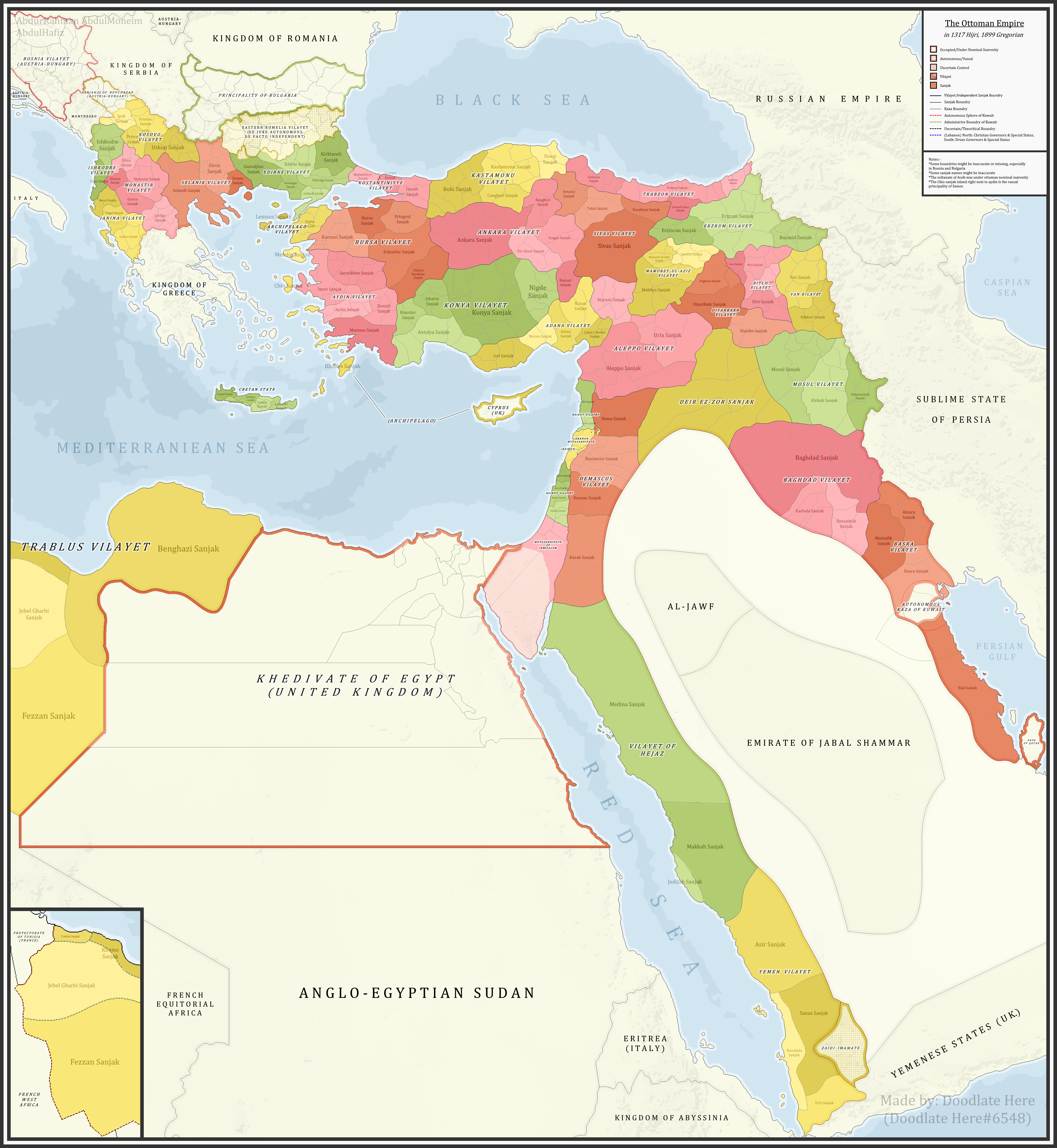
English: A detailed map showing the Ottoman Empire and its dependencies, including its administrative divisions, in 1899 CE (1317 Hijri). |
| तारीख | |
| स्रोत |
आपन रचना References:The sources that back up the maps are as follows: [1] Pavet de Courteille, Abel (1876). État présent de l'empire ottoman (in French). J. Dumaine. pp. 91–96. (for Yemen) [2] http://tarihvemedeniyet.org/2009/10/trablus-garb-vilayeti.html for Tripolitania [3] http://tarihvemedeniyet.org/2009/10/bosna-vilayeti.html for Bosnia [4] https://www.nsi.bg/nrnm/index.php?i=1&ezik=en for eastern Rumelia [5] http://hdl.loc.gov/loc.gmd/g7431f.ct002181 (Rest of Ottoman subdivisions, taken from the United States Library of Congress's Geography & Map Division, digital ID g7431f.ct002181) |
| लेखक | AbdurRahman AbdulMoneim |
| Other versions |



लाइसेंसिंग


- आप फ्री बानी:
- साझा करे खातिर – रचना के नकल करे, बाँटे आ दुसरी जगह भेजे खातिर
- रीमिक्स करे खातिर – काम के अपनी हिसाब से बनावे खातिर
- नीचे दिहल कारणन की तहत:
- एट्रीब्यूशन – लाइसेंस के कड़ी दे के उचित श्रेय (क्रेडिट) दिहल जरूरी बा आ अगर कौनों बदलाव कइल गइल बा तब ओहू के बतावल जाए के चाहीं। आप ई काम कौनों उचित तरीका से क सकत बानी, बाकी ई न झलके के चाहीं की जेकरा लगे लाइसेंस बा ऊ राउर चाहे राउर काम के समर्थन करत बाटे या सही बतावत बा।
- शेयर अलाइक (share alike) – अगर आप एह सामग्री के आधार बना के कुछ रिमिक्स करत बानी, रूप बदलाव करत बानी, चाहे कुछ जोड़ के सामग्री के बढ़ावत बानी, आपके आपन योगदान ठीक एही या कंपेटिबल लाइसेंस जइसन कि ओरिजनल बाटे, के तहत होखे के चाहीं।
| Annotations InfoField | This image is annotated: View the annotations at Commons |

The sources that back up the maps are as follows:
[1] Pavet de Courteille, Abel (1876). État présent de l'empire ottoman (in French). J. Dumaine. pp. 91–96. (for Yemen)
[2] http://tarihvemedeniyet.org/2009/10/trablus-garb-vilayeti.html for Tripolitania
[3] http://tarihvemedeniyet.org/2009/10/bosna-vilayeti.html for Bosnia
[4] https://www.nsi.bg/nrnm/index.php?i=1&ezik=en for eastern Rumelia
[5] http://hdl.loc.gov/loc.gmd/g7431f.ct002181 (Rest of Ottoman subdivisions, taken from the United States Library of Congress's Geography & Map Division, digital ID g7431f.ct002181)
Captions
फाइल के इतिहास
ओ समय ई फाइल कइसन लउके ई देखे खातिर कौनों तारीख/समय पर क्लिक करीं।
| तारीख/समय | चिप्पी रूप | डाइमेंशन | प्रयोगकर्ता | टिप्पणी | |
|---|---|---|---|---|---|
| वर्तमान | १२:४६, १६ नवंबर २०२१ | Error creating thumbnail: File with dimensions greater than १२.५ MP | ४,४५५ × ४,८४० (२.१ MB) | smartcommons>BasilLeaf | updates |
फाइल के उपयोग
कौनों पन्ना नइखे जवन ए फाइल के इस्तेमाल करत होखे।
