चित्र:Ottomans 1875.png
Error creating thumbnail: File with dimensions greater than १२.५ MP
अउरी resolution: ५,३८४ × ५,९७६ पिक्सेल.
ओरिजनल फाइल (५,३८४ × ५,९७६ पिक्सेल, फाइल साइज: ६.४७ MB, MIME टाइप: image/png)

|
This map image could be re-created using vector graphics as a SVG file. This has several advantages; see Commons:Media for cleanup for more information. If a SVG form of this image is available, please upload it and afterwards replace this template with
{{vector version available|new image name}}.It is recommended to name the SVG file “Ottomans 1875.svg”—then the template Vector version available (or Vva) does not need the new image name parameter. |



सारांश
| बिबरणOttomans 1875.png |
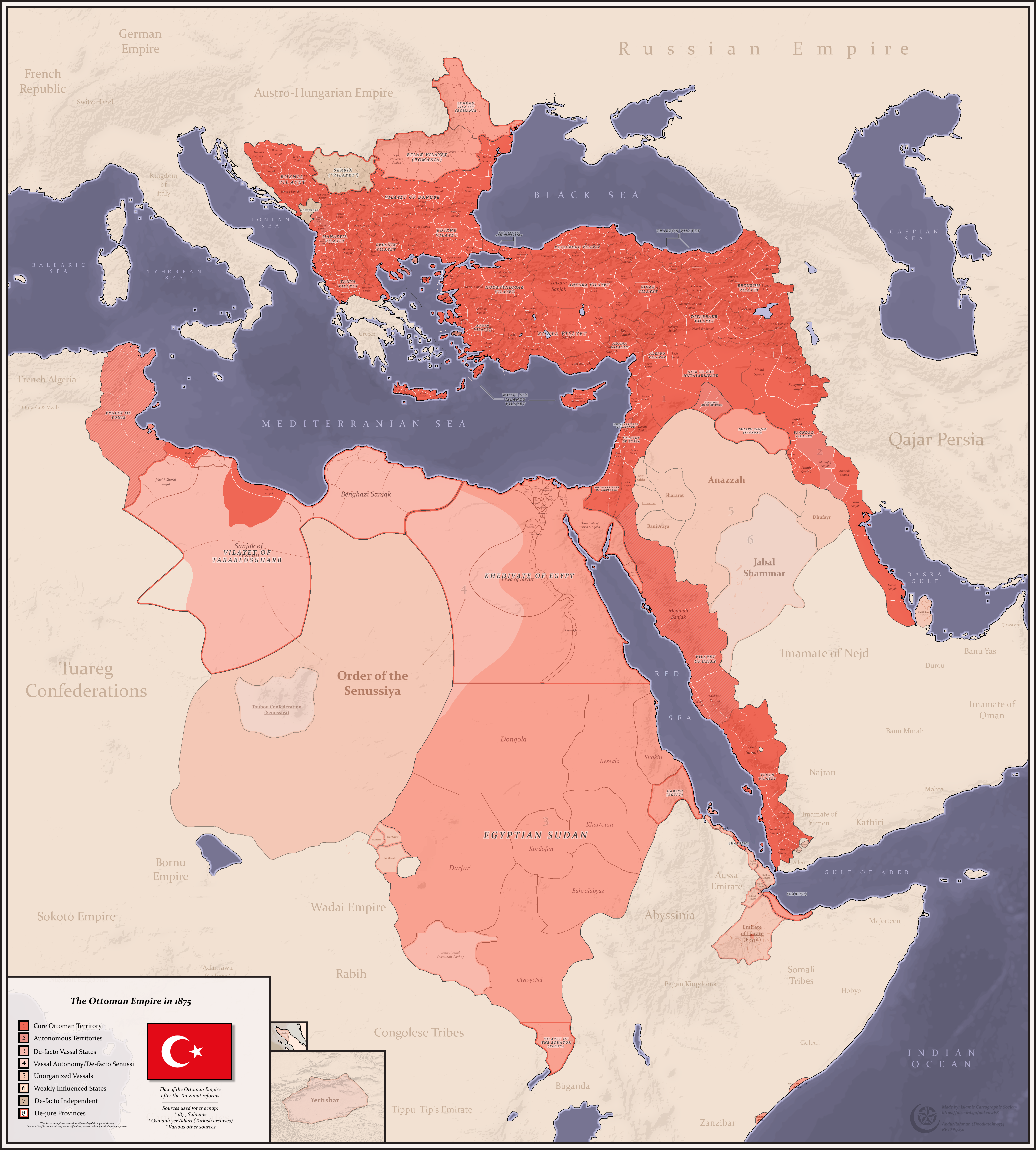
English: A Detailed map of the Ottoman Empire, it's divisions and vassals in the gregorian year 1875
Sources: - Salname of 1875 - Osmanli yer Adlari (from turkish archives) - Other sources |
| तारीख | |
| स्रोत | आपन रचना |
| लेखक | AbdurRahman AbdulMoneim |
लाइसेंसिंग
I, the copyright holder of this work, hereby publish it under the following license:


This file is licensed under the Creative Commons Attribution-Share Alike 4.0 International license.
- आप फ्री बानी:
- साझा करे खातिर – रचना के नकल करे, बाँटे आ दुसरी जगह भेजे खातिर
- रीमिक्स करे खातिर – काम के अपनी हिसाब से बनावे खातिर
- नीचे दिहल कारणन की तहत:
- एट्रीब्यूशन – लाइसेंस के कड़ी दे के उचित श्रेय (क्रेडिट) दिहल जरूरी बा आ अगर कौनों बदलाव कइल गइल बा तब ओहू के बतावल जाए के चाहीं। आप ई काम कौनों उचित तरीका से क सकत बानी, बाकी ई न झलके के चाहीं की जेकरा लगे लाइसेंस बा ऊ राउर चाहे राउर काम के समर्थन करत बाटे या सही बतावत बा।
- शेयर अलाइक (share alike) – अगर आप एह सामग्री के आधार बना के कुछ रिमिक्स करत बानी, रूप बदलाव करत बानी, चाहे कुछ जोड़ के सामग्री के बढ़ावत बानी, आपके आपन योगदान ठीक एही या कंपेटिबल लाइसेंस जइसन कि ओरिजनल बाटे, के तहत होखे के चाहीं।
Captions
Add a one-line explanation of what this file represents
Detailed map of the Ottoman Empire in the gregorian year 1875
फाइल के इतिहास
ओ समय ई फाइल कइसन लउके ई देखे खातिर कौनों तारीख/समय पर क्लिक करीं।
| तारीख/समय | चिप्पी रूप | डाइमेंशन | प्रयोगकर्ता | टिप्पणी | |
|---|---|---|---|---|---|
| वर्तमान | १४:१३, २८ जनवरी २०२२ | Error creating thumbnail: File with dimensions greater than १२.५ MP | ५,३८४ × ५,९७६ (६.४७ MB) | smartcommons>Userd898 | better representation of tunisia |
फाइल के उपयोग
कौनों पन्ना नइखे जवन ए फाइल के इस्तेमाल करत होखे।
