चित्र:Pallava territories.png

ए नमूना के साइज: २२० × ११७ पिक्सेल. अउरी resolution: २७० × १४३ पिक्सेल.
ओरिजनल फाइल (२७० × १४३ पिक्सेल, फाइल साइज: ९ KB, MIME टाइप: image/png)

सारांश

|
This map has been uploaded by Electionworld from en.wikipedia.org to enable the  Wikimedia Atlas of the World . Original uploader to en.wikipedia.org was Venu62, known as Venu62 at en.wikipedia.org. Electionworld is not the creator of this map. Licensing information is below. Wikimedia Atlas of the World . Original uploader to en.wikipedia.org was Venu62, known as Venu62 at en.wikipedia.org. Electionworld is not the creator of this map. Licensing information is below.
|
Pallava territories during Narasimhavarman I c. 645 CE. This includes the Chalukya territories occupied by the Pallavas.
Map created using the Wikipedia blank maps and modified using Adobe Photoshop
map shown here cotradicts the map shown in calukya period webpage. please retain yhe one which is historically accurate
लाइसेंसिंग
Venu62, the copyright holder of this work, hereby publishes it under the following license:

|
जीएनयू फ्री डाकुमेंटेशन लाइसेंस, वर्जन 1.2 या फिर कौनो भी बाद के प्रकाशित फ्री साफ्टवेयर फाउंडेशन लाइसेंस के शर्त के तहत, एह डाकुमेंट के नकल करे, बितरण करे आ/भा बदलाव करे के परमीशन दिहल गइल बा; एह में इनवैरिएंट खंड सभ नइखे शामिल, मुखपृष्ट के पाठ नइखे शामिल, आ बैक-कभर के पाठ नइखे शामिल। लाइसेंस के एगो प्रति जीएनयू फ्री डाकुमेंटेशन लाइसेंस नाँव के खंड में दिहल गइल बा।http://www.gnu.org/copyleft/fdl.htmlGFDLGNU Free Documentation Licensetruetrue |
  
|
ई फाइल Creative Commons Attribution-Share Alike 3.0 Unported लाइसेंस की तहत लाइसेंसी बा। | |
एट्रीब्यूशन:
| ||
| ||
| This licensing tag was added to this file as part of the GFDL licensing update.http://creativecommons.org/licenses/by-sa/3.0/CC BY-SA 3.0Creative Commons Attribution-Share Alike 3.0truetrue |
Captions
Add a one-line explanation of what this file represents
फाइल के इतिहास
ओ समय ई फाइल कइसन लउके ई देखे खातिर कौनों तारीख/समय पर क्लिक करीं।
| तारीख/समय | चिप्पी रूप | डाइमेंशन | प्रयोगकर्ता | टिप्पणी | |
|---|---|---|---|---|---|
| वर्तमान | ०४:५९, १४ दिसंबर २००६ | 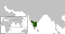 | २७० × १४३ (९ KB) | smartcommons>Electionworld | {{ew|en|Venu62}} Pallava territories during Narasimhavarman I c. 645 CE. This includes the Chalukya territories occupied by the Pallavas. Map created using the Wikipedia blank maps and modified using Adobe Photoshop map shown here cotradicts the |
फाइल के उपयोग
कौनों पन्ना नइखे जवन ए फाइल के इस्तेमाल करत होखे।
