चित्र:Punjab-Districts 1911.png

ए नमूना के साइज: २२० × १७३ पिक्सेल. अउरी रिजोल्यूशन: ३०५ × २४० पिक्सेल | ५६९ × ४४८ पिक्सेल.
ओरिजनल फाइल (५६९ × ४४८ पिक्सेल, फाइल साइज: ११३ KB, MIME टाइप: image/png)

सारांश
| बिबरणPunjab-Districts 1911.png |
English: Map of the Districts and some Indian Princely States (Bahawalpur, Sirmur, Suket, Chamba etc.) of the Punjab, 1911
Deutsch: Karte der Distrikte des Punjab und einiger darin eingeschlossener indischer Fürstenstaaten (Bahawalpur, Sirmur, Suket, Chamba ), 1911. Höhenangaben in Fuß. |
| तारीख | |
| स्रोत | Provincial Geographies of India, Vol. III |
| लेखक | Sir Henry |
लाइसेंसिंग
| Public domainPublic domainfalsefalse |

|
This work is in the public domain in its country of origin and other countries and areas where the copyright term is the author's life plus 70 years or fewer.  You must also include a United States public domain tag to indicate why this work is in the public domain in the United States. You must also include a United States public domain tag to indicate why this work is in the public domain in the United States.
|
| This file has been identified as being free of known restrictions under copyright law, including all related and neighboring rights. | |
https://creativecommons.org/publicdomain/mark/1.0/PDMCreative Commons Public Domain Mark 1.0falsefalse
Captions
Add a one-line explanation of what this file represents
Districts and princely states of Punjab, 1911
1911 ਦੇ ਪੰਜਾਬ ਦੇ ਜ਼ਿਲ੍ਹਿਆਂ ਅਤੇ ਕੁਝ ਭਾਰਤੀ ਰਿਆਸਤਾਂ (ਬਹਾਵਲਪੁਰ, ਸਿਰਮੁਰ, ਸੁਕੇਤ, ਚੰਬਾ ਆਦਿ) ਦਾ ਨਕਸ਼ਾ।
फाइल के इतिहास
ओ समय ई फाइल कइसन लउके ई देखे खातिर कौनों तारीख/समय पर क्लिक करीं।
| तारीख/समय | चिप्पी रूप | डाइमेंशन | प्रयोगकर्ता | टिप्पणी | |
|---|---|---|---|---|---|
| वर्तमान | १३:४२, २९ जून २०१४ | 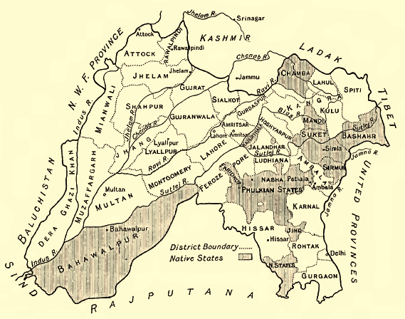 | ५६९ × ४४८ (११३ KB) | smartcommons>Xufanc | sepia color |
फाइल के उपयोग
कौनों पन्ना नइखे जवन ए फाइल के इस्तेमाल करत होखे।
