चित्र:Riogranderift sanluisbasin.png

ओरिजनल फाइल (२,२८० × १,०७४ पिक्सेल, फाइल साइज: १.१७ MB, MIME टाइप: image/png)

सारांश
utdlabrador, after B. Brister & R. Gries, Tertiary Stratigraphy and Tectonic Development of the Alamosa Basin (Northern San Luis Basin), Rio Grande Rift, South Central Colorado.
लाइसेंसिंग
| Public domainPublic domainfalsefalse |

|
I, the copyright holder of this work, release this work into the public domain. This applies worldwide. In some countries this may not be legally possible; if so: I grant anyone the right to use this work for any purpose, without any conditions, unless such conditions are required by law. |
FYI, the legend on this diagram has an error. The green color (2nd-youngest division shown) is labeled "Paleocene alluvium and sediments". However, the Paleocene Epoch is older than the Eocene and Oligocene-age layers shown on the map, so this cannot be the correct name for sediments in this upper layer. This color must represent Miocene + Pliocene sediments, which collectively are grouped as the rocks of the Neogene Period.
Captions
फाइल के इतिहास
ओ समय ई फाइल कइसन लउके ई देखे खातिर कौनों तारीख/समय पर क्लिक करीं।
| तारीख/समय | चिप्पी रूप | डाइमेंशन | प्रयोगकर्ता | टिप्पणी | |
|---|---|---|---|---|---|
| वर्तमान | १२:४२, ५ दिसंबर २०१० | 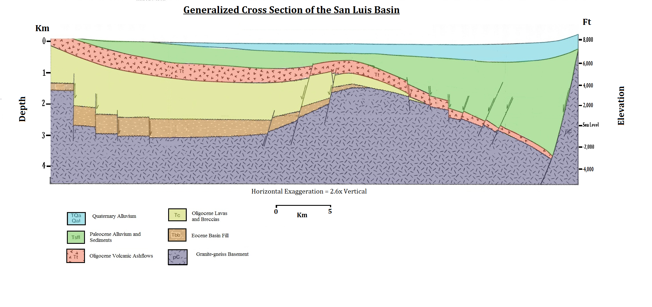 | २,२८० × १,०७४ (१.१७ MB) | smartcommons>Utdlabrador | utdlabrador, after B. Brister & R. Gries, '''Tertiary Stratigraphy and Tectonic Development of the Alamosa Basin (Northern San Luis Basin), Rio Grande Rift, South Central Colorado'''. |
फाइल के उपयोग
कौनों पन्ना नइखे जवन ए फाइल के इस्तेमाल करत होखे।
