चित्र:Seljuk Empire locator map.svg

Size of this PNG preview of this SVG file: २२० × १३४ पिक्सेल. अउरी resolution: ३२० × १९५ पिक्सेल.
ओरिजनल फाइल (एसवीजी फाइल, नॉमिनली ८०० x ४८८ पिक्सल, फाइल के आकार: १६१ KB)

सारांश
| बिबरणSeljuk Empire locator map.svg |
English: A map showing the Great Seljuk Empire at its height, upon the death of Malik Shah I in 1092.
Nederlands: Het Seltsjoekenrijk op het toppunt van haar macht in nl:1092, ten tijde van de dood van nl:Malik Sjah I. Na diens dood viel het rijk uiteen in verschillende staatjes. |
| तारीख | |
| स्रोत | आपन रचना |
| लेखक | MapMaster |
| Other versions | File:Seljuk Empire correct locator map.png (reportedly more correct, but unfortunately PNG) |

References
- Black, Jeremy The Atlas of World History, Covent Garden Books, American Edition, New York, p. p. 228 , ISBN 9780756618612
- Grousset, René (1970) The Empire of the Steppes: A History of Central Asia, New Brunswick:Rutgers University Press, 8th paperback edition, 2002, p. 156.
- Hall, Simon and John Haywood (1997) The Complete Atlas of World History: The Medieval & Early Modern World, A.D. 600 - 1783, Armonk, NY: Sharpe Reference.
- Holt, Peter Malcolm; Ann K. S. Lambton; Bernard Lewis (1977) The Cambridge history of Islam, Volume 1, p, 260, ISBN 978-0521291354.
- Hourani, Albert (1991) A History of the Arab Peoples, Cambridge, Massachusetts: The Belknap Press of Harvard University Press, p. 467.
- Shepherd, William (1911) "Europe and the Mediterranean Lands about 1097", Historical Atlas, New York: Henry Holt and Company.
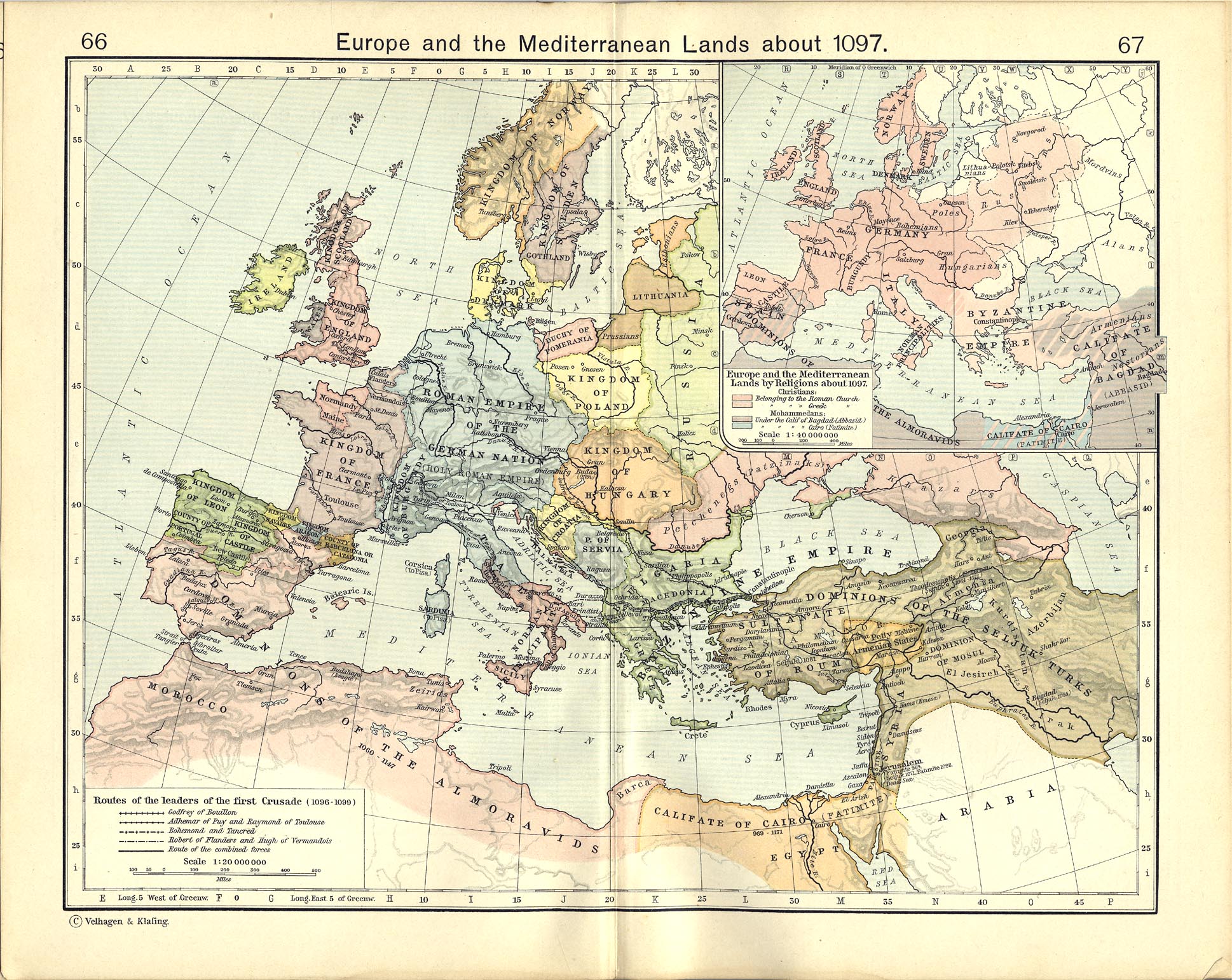
In general, the map was based on Shepherd and on Hall & Haywood, with modifications based on Grousset and Hourani (Hourani's map excludes the area retaken by Byzantium and the Crusaders in 1097-1100). Other maps show the Empire extending into present day Pakistan &/or that include Mecca, but I have found little evidence to support this.
लाइसेंसिंग
I, the copyright holder of this work, hereby publish it under the following licenses:

|
जीएनयू फ्री डाकुमेंटेशन लाइसेंस, वर्जन 1.2 या फिर कौनो भी बाद के प्रकाशित फ्री साफ्टवेयर फाउंडेशन लाइसेंस के शर्त के तहत, एह डाकुमेंट के नकल करे, बितरण करे आ/भा बदलाव करे के परमीशन दिहल गइल बा; एह में इनवैरिएंट खंड सभ नइखे शामिल, मुखपृष्ट के पाठ नइखे शामिल, आ बैक-कभर के पाठ नइखे शामिल। लाइसेंस के एगो प्रति जीएनयू फ्री डाकुमेंटेशन लाइसेंस नाँव के खंड में दिहल गइल बा।http://www.gnu.org/copyleft/fdl.htmlGFDLGNU Free Documentation Licensetruetrue |


This file is licensed under the Creative Commons Attribution-Share Alike 4.0 International, 3.0 Unported, 2.5 Generic, 2.0 Generic and 1.0 Generic license.
- आप फ्री बानी:
- साझा करे खातिर – रचना के नकल करे, बाँटे आ दुसरी जगह भेजे खातिर
- रीमिक्स करे खातिर – काम के अपनी हिसाब से बनावे खातिर
- नीचे दिहल कारणन की तहत:
- एट्रीब्यूशन – लाइसेंस के कड़ी दे के उचित श्रेय (क्रेडिट) दिहल जरूरी बा आ अगर कौनों बदलाव कइल गइल बा तब ओहू के बतावल जाए के चाहीं। आप ई काम कौनों उचित तरीका से क सकत बानी, बाकी ई न झलके के चाहीं की जेकरा लगे लाइसेंस बा ऊ राउर चाहे राउर काम के समर्थन करत बाटे या सही बतावत बा।
- शेयर अलाइक (share alike) – अगर आप एह सामग्री के आधार बना के कुछ रिमिक्स करत बानी, रूप बदलाव करत बानी, चाहे कुछ जोड़ के सामग्री के बढ़ावत बानी, आपके आपन योगदान ठीक एही या कंपेटिबल लाइसेंस जइसन कि ओरिजनल बाटे, के तहत होखे के चाहीं।
रउआँ अपनी जरूरत के लाइसेंस बीछ सकत बानीं।
Captions
Add a one-line explanation of what this file represents
گستردگی مرزهای ایران در دورهٔ سلجوقیان در زمان مرگ سلطان ملک شاه.
फाइल के इतिहास
ओ समय ई फाइल कइसन लउके ई देखे खातिर कौनों तारीख/समय पर क्लिक करीं।
| तारीख/समय | चिप्पी रूप | डाइमेंशन | प्रयोगकर्ता | टिप्पणी | |
|---|---|---|---|---|---|
| वर्तमान | १८:५४, ५ जून २०१४ | 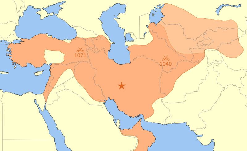 | ८०० × ४८८ (१६१ KB) | smartcommons>Ras67 | frame removed |
फाइल के उपयोग
कौनों पन्ना नइखे जवन ए फाइल के इस्तेमाल करत होखे।
