चित्र:Tibet provinces.png

ए नमूना के साइज: २२० × १५३ पिक्सेल. अउरी रिजोल्यूशन: ३२० × २२२ पिक्सेल | १,४२१ × ९८६ पिक्सेल.
ओरिजनल फाइल (१,४२१ × ९८६ पिक्सेल, फाइल साइज: ८७१ KB, MIME टाइप: image/png)

| बिबरणTibet provinces.png |
English: A simple map of the three traditional provinces of Tibet overlaid on a map of modern provincial boundaries of the People's Republic of China. |
| तारीख | (UTC) |
| स्रोत | |
| लेखक |
|

 |
This is a retouched picture, which means that it has been digitally altered from its original version. Modifications: added traditional provinces overlay. The original can be viewed here: Map of Tibet Ü-Tsang Amdo and Kham.jpg:  . Modifications made by Kmusser. . Modifications made by Kmusser.
|


ई फाइल Creative Commons Attribution-Share Alike 3.0 Unported लाइसेंस की तहत लाइसेंसी बा।
- आप फ्री बानी:
- साझा करे खातिर – रचना के नकल करे, बाँटे आ दुसरी जगह भेजे खातिर
- रीमिक्स करे खातिर – काम के अपनी हिसाब से बनावे खातिर
- नीचे दिहल कारणन की तहत:
- एट्रीब्यूशन – लाइसेंस के कड़ी दे के उचित श्रेय (क्रेडिट) दिहल जरूरी बा आ अगर कौनों बदलाव कइल गइल बा तब ओहू के बतावल जाए के चाहीं। आप ई काम कौनों उचित तरीका से क सकत बानी, बाकी ई न झलके के चाहीं की जेकरा लगे लाइसेंस बा ऊ राउर चाहे राउर काम के समर्थन करत बाटे या सही बतावत बा।
- शेयर अलाइक (share alike) – अगर आप एह सामग्री के आधार बना के कुछ रिमिक्स करत बानी, रूप बदलाव करत बानी, चाहे कुछ जोड़ के सामग्री के बढ़ावत बानी, आपके आपन योगदान ठीक एही या कंपेटिबल लाइसेंस जइसन कि ओरिजनल बाटे, के तहत होखे के चाहीं।
Original upload log
This image is a derivative work of the following images:
- File:Tibet&neighbors_Locator_map.svg licensed with Cc-by-sa-3.0, GFDL
- 2009-10-13T22:22:54Z Keithonearth 1520x1059 (188220 Bytes) {{Information |Description={{en|1=A simple map of the Tibetan Autonomous Region, and surrounding Nations, and States. It was made for [[:en:Template:Location map China Tibet]].}} |Source={{own}} |Author=[[User:Keithonearth|K
- File:Map_of_Tibet_Ü-Tsang_Amdo_and_Kham.jpg licensed with Cc-by-sa-2.5
Uploaded with derivativeFX
Captions
Add a one-line explanation of what this file represents
This map of Tibet represents the current population of Tibetans residing in this region. The historical Tibetan empire extended from Samarkhand in Uzbekistan to Changan (Xian) in China.
फाइल के इतिहास
ओ समय ई फाइल कइसन लउके ई देखे खातिर कौनों तारीख/समय पर क्लिक करीं।
| तारीख/समय | चिप्पी रूप | डाइमेंशन | प्रयोगकर्ता | टिप्पणी | |
|---|---|---|---|---|---|
| वर्तमान | ०३:०५, २८ मार्च २०११ | 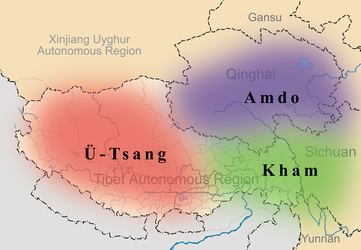 | १,४२१ × ९८६ (८७१ KB) | smartcommons>Kmusser | {{Information |Description={{en|1=A simple map of the three traditional provinces of Tibet overlaid on a map of modern provincial boundaries of the People's Republic of China.}} == |Source=*File:Tibet&neighbors_Locator_map.svg *[[:File:Map_of_Tibet_ |

फाइल के उपयोग
कौनों पन्ना नइखे जवन ए फाइल के इस्तेमाल करत होखे।
