चित्र:Trigonometrical Plan of the Island and Harbour of Bahrain.jpg

ए नमूना के साइज: २२० × २४९ पिक्सेल. अउरी रिजोल्यूशन: २१२ × २४० पिक्सेल | २,०९८ × २,३७६ पिक्सेल.
ओरिजनल फाइल (२,०९८ × २,३७६ पिक्सेल, फाइल साइज: १.८ MB, MIME टाइप: image/jpeg)
सारांश
| बिबरणTrigonometrical Plan of the Island and Harbour of Bahrain.jpg |
English: "‘Trigonometrical Plan of the Island and Harbour of Bahrein, on the Arabian Side of the Gulf of Persia; by Lieutts. G.B. Brucks, and W.E. Rogers. Hon. E.I.C. Marine Service: 1825. Drawn by Lieutt. M. Houghton; Draughtsman Hon. E.I.C. Marine. Engraved by Bateman and Son’" |
| तारीख | |
| स्रोत | Qatar Digital Library |
| लेखक | by Lieutts. G.B. Brucks, and W.E. Rogers. Hon. E.I.C. Marine Service: 1825. Drawn by Lieutt. M. Houghton; Draughtsman Hon. E.I.C. Marine |
| Other versions |


लाइसेंसिंग
_(St_Edwards_Crown).svg)
|
This file is licensed under the Open Government Licence version 1.0 (OGL v1.0).
|
|---|---|
| एट्रीब्यूशन: 1 | |
|
You are free to:
See the Open Government Licence page on Meta-Wiki for more information. http://NationalArchives.gov.uk/doc/open-government-licence/version/1/ OGL v1.0 Open Government License version 1.0 true truehttp://NationalArchives.gov.uk/doc/open-government-licence/version/1/ OGL v1.0 Open Government License version 1.0 true true |
Captions
Add a one-line explanation of what this file represents
Trigonometrical plan of Bahrain and Manama Harbor, 1825.
बहरीन और मनामा हार्बर का त्रिकोणमितीय योजना, 1825
फाइल के इतिहास
ओ समय ई फाइल कइसन लउके ई देखे खातिर कौनों तारीख/समय पर क्लिक करीं।
| तारीख/समय | चिप्पी रूप | डाइमेंशन | प्रयोगकर्ता | टिप्पणी | |
|---|---|---|---|---|---|
| वर्तमान | ०६:१०, ११ जनवरी २०१९ | 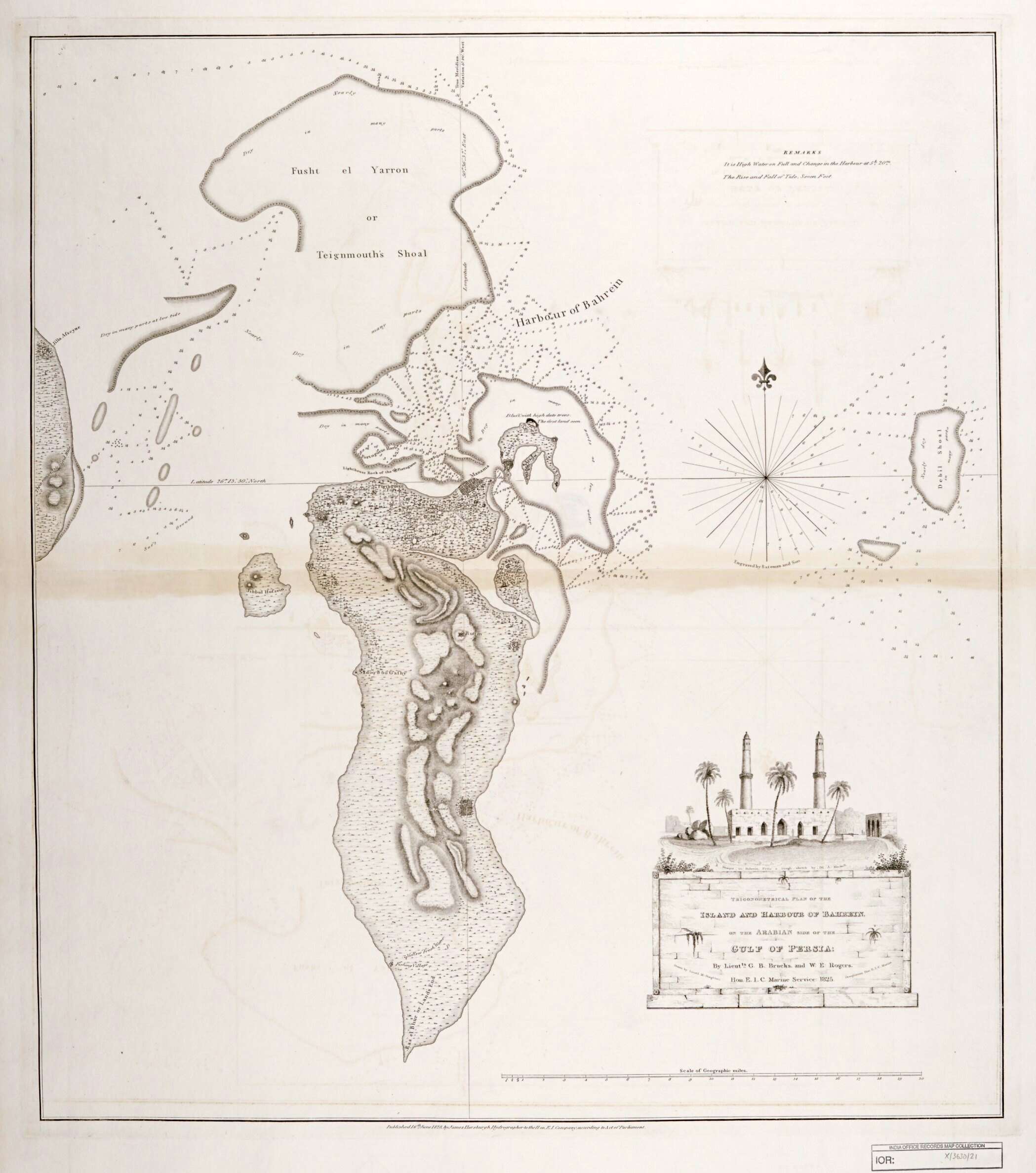 | २,०९८ × २,३७६ (१.८ MB) | smartcommons>Elspamo4 | Cropped, adjusted contrast |
फाइल के उपयोग
कौनों पन्ना नइखे जवन ए फाइल के इस्तेमाल करत होखे।
