चित्र:US Overflight Fee Map.png

ए नमूना के साइज: २२० × १६० पिक्सेल. अउरी रिजोल्यूशन: ३२० × २३२ पिक्सेल | ३७५ × २७२ पिक्सेल.
ओरिजनल फाइल (३७५ × २७२ पिक्सेल, फाइल साइज: २८ KB, MIME टाइप: image/png)


|
This image could be re-created using vector graphics as a SVG file. This has several advantages; see Commons:Media for cleanup for more information. If a SVG form of this image is available, please upload it and afterwards replace this template with
{{vector version available|new image name}}.It is recommended to name the SVG file “US Overflight Fee Map.svg”—then the template Vector version available (or Vva) does not need the new image name parameter. |
सारांश
| बिबरणUS Overflight Fee Map.png |
English: A map of the regions where the United States charges overflight fees. Yellow is where higher "enroute" fees are charged. Blue is where "oceanic" fees are charged. The colored regions of this map correspond to the regions where the US has delegated authority by the ICAO to control air traffic, including over international waters. |
| तारीख | Unknown date |
| स्रोत | http://www.faa.gov/about/office_org/headquarters_offices/aba/overflight_fees/ |
| लेखक | Federal Aviation Administration |
लाइसेंसिंग
| Public domainPublic domainfalsefalse |

|
This image or file is a work of a Federal Aviation Administration employee, taken or made as part of that person's official duties. As a work of the U.S. federal government, the image is in the public domain in the United States.
|
 |
फाइल के इतिहास
ओ समय ई फाइल कइसन लउके ई देखे खातिर कौनों तारीख/समय पर क्लिक करीं।
| तारीख/समय | चिप्पी रूप | डाइमेंशन | प्रयोगकर्ता | टिप्पणी | |
|---|---|---|---|---|---|
| वर्तमान | ०८:२२, ९ अगस्त २०१४ | 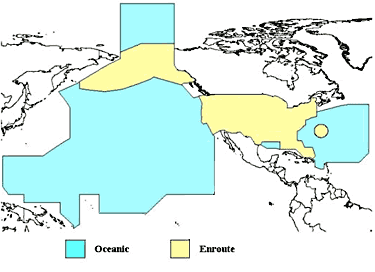 | ३७५ × २७२ (२८ KB) | smartcommons>AHeneen | User created page with UploadWizard |
फाइल के उपयोग
कौनों पन्ना नइखे जवन ए फाइल के इस्तेमाल करत होखे।
