चित्र:Vichy france map.png

ए नमूना के साइज: २१९ × ९६ पिक्सेल. अउरी रिजोल्यूशन: ३२० × १४० पिक्सेल | १,४२५ × ६२५ पिक्सेल.
ओरिजनल फाइल (१,४२५ × ६२५ पिक्सेल, फाइल साइज: ५० KB, MIME टाइप: image/png)

सारांश
| बिबरणVichy france map.png |
English: Map of Vichy France and the loss of its territory to Free France and the Axis powers. Legend:
日本語: フランスの領土・植民地のうちヴィシーフランスと自由フランス、枢軸国占領地域の地図。凡例:
Русский: Карта Вишистской Франции и потеря ею территорий Свободной Франции и странам «Оси»:
Français : Carte de la France de Vichy et de la perte de ses territoires au profit de la France libre et des puissances de l'Axe. Légende :
|
| स्रोत | |
| लेखक |
लाइसेंसिंग
| Public domainPublic domainfalsefalse |

|
This work has been released into the public domain by its author, VoodooIsland at अंगरेजी विकिपीडिया. This applies worldwide. In some countries this may not be legally possible; if so: VoodooIsland grants anyone the right to use this work for any purpose, without any conditions, unless such conditions are required by law.Public domainPublic domainfalsefalse |
Original upload log
The original description page was here. All following user names refer to en.wikipedia.

- 2011-03-01 19:23 Morgan Hauser 1425×774× (58113 bytes) Added Franco-Belgian border, corrected Alsace-Lorraine, the Demarcation line and the Algerian internal boundary weren't country borders, Corsica was Vichy until 1942, corrected the Italian zone of occupation.
- 2010-07-11 20:50 VoodooIsland 1425×774× (63452 bytes) designate concessions (held by Vichy until 1943) in China
- 2010-07-11 20:10 VoodooIsland 1425×774× (63369 bytes) designate Algerian territory integral to French State vs that held as colony
- 2010-05-29 23:51 VoodooIsland 1425×774× (63306 bytes) Forgot to downgrade color of New Caledonia (Vichy gov. speedily extinguished)
- 2010-05-29 23:46 VoodooIsland 1425×774× (63302 bytes) +French territories '''never'' held by Vichy France (e.g., only [[French India]])
- 2010-05-29 23:43 VoodooIsland 1425×774× (63266 bytes) +Itallian occupation zone in southeast
- 2010-05-29 22:57 VoodooIsland 1425×774× (63239 bytes) +Alsace-Lorraine (Nazi occupied)
- 2010-05-29 22:48 VoodooIsland 1425×774× (63228 bytes) Nazi Germany occupied Northern part while formally part of the French State
- 2010-05-29 22:44 VoodooIsland 1425×774× (63159 bytes) '''Dark blue:''' ''De jure'' part of the '''French State''' ("[[Vichy France]]") '''Teal:''' ''De jure'' part of the '''French State''' ("[[Vichy France]]") under [[Fascist Italy|Italian]] occupation '''Light blue:''' [[League of Nations mandate|Mandate]]
| Annotations InfoField | This image is annotated: View the annotations at Commons |

770
185
45
50
1425
774
Operation Exporter took place in the League of Nations French Mandate for Syria and the Lebanon between 8 June and 14 July 1941.
670
306
39
57
1425
774
The League of Nations mandate of French Cameroun joined Free France on 27 August 1940.
Captions
Add a one-line explanation of what this file represents
Gradual Loss of Vichy France's (French State) colonies
Perte graduelle des colonies françaises du régime de Vichy (État français)
फाइल के इतिहास
ओ समय ई फाइल कइसन लउके ई देखे खातिर कौनों तारीख/समय पर क्लिक करीं।
| तारीख/समय | चिप्पी रूप | डाइमेंशन | प्रयोगकर्ता | टिप्पणी | |
|---|---|---|---|---|---|
| वर्तमान | ०२:५८, २२ मई २०१७ | 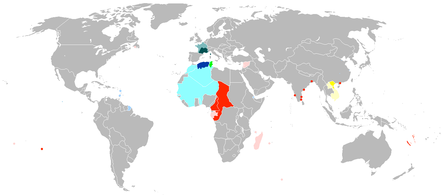 | १,४२५ × ६२५ (५० KB) | smartcommons>Grachifan | cutting extra space at the bottom of the image |
फाइल के उपयोग
कौनों पन्ना नइखे जवन ए फाइल के इस्तेमाल करत होखे।
