चित्र:World Trade Center, NY - 2001-09-11 - Debris Impact Areas.svg

Size of this PNG preview of this SVG file: २२० × २५३ पिक्सेल. अउरी resolution: २०९ × २४० पिक्सेल.
ओरिजनल फाइल (एसवीजी फाइल, नॉमिनली २,११० x २,४२६ पिक्सल, फाइल के आकार: २०३ KB)
| बिबरणWorld Trade Center, NY - 2001-09-11 - Debris Impact Areas.svg |
English: A diagram showing the areas where debris from American Airlines Flight 11 and United Airlines Flight 175 fell upon Lower Manhattan during the course of the September 11 terror attacks. |
||
| तारीख | |||
| स्रोत | Own work. Derived from 911 - FEMA - Areas debris impact (graphic).png by Therese McAllister, Jonathan Barnett, John Gross, Ronald Hamburger, Jon Magnuson of the Federal Emergency Management Agency (FEMA) of the United States Department of Homeland Security. As a work of the United States government, it was released to the public domain. It can be located on page 6 of this FEMA study. | ||
| लेखक | Cflm001 (बातचीत) | ||
| परमीशन (एह फाइल के दुबारा इस्तेमाल) |
I, the copyright holder of this work, hereby publish it under the following licenses:
   ई फाइल Creative Commons Attribution-Share Alike 3.0 Unported लाइसेंस की तहत लाइसेंसी बा।
रउआँ अपनी जरूरत के लाइसेंस बीछ सकत बानीं। |
||
| Other versions |
This file was derived from: 911 - FEMA - Areas debris impact (graphic).png: .png) |
||
| SVG genesis InfoField |  This diagram was created with Adobe Illustrator. This diagram was created with Adobe Illustrator. |


Captions
Add a one-line explanation of what this file represents
Схема попадания самолётов в башни ВТЦ
फाइल के इतिहास
ओ समय ई फाइल कइसन लउके ई देखे खातिर कौनों तारीख/समय पर क्लिक करीं।
| तारीख/समय | चिप्पी रूप | डाइमेंशन | प्रयोगकर्ता | टिप्पणी | |
|---|---|---|---|---|---|
| वर्तमान | ०८:४०, ११ सितंबर २०२२ | 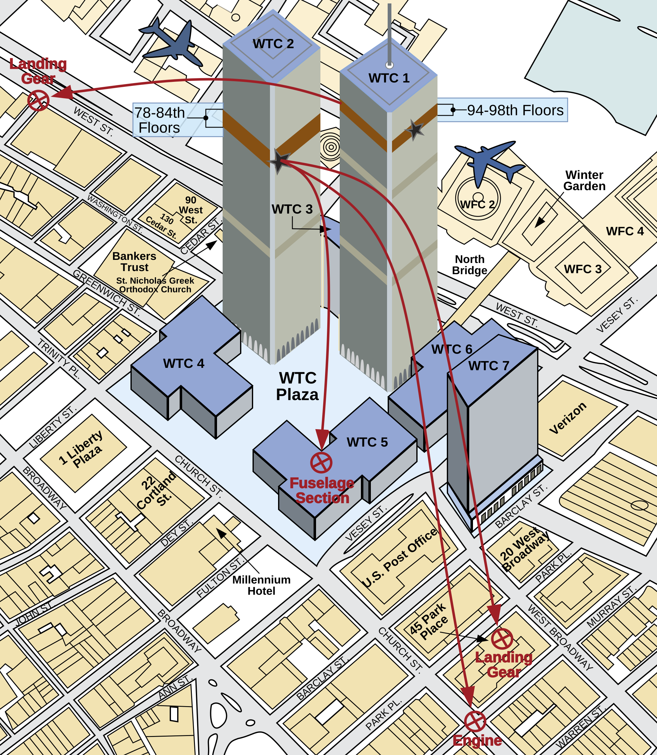 | २,११० × २,४२६ (२०३ KB) | smartcommons>YitzhakNat | using inkscapeː fix shadow |
फाइल के उपयोग
कौनों पन्ना नइखे जवन ए फाइल के इस्तेमाल करत होखे।
