चित्र:RomanEmpire 117.svg
Error creating thumbnail: फाइल गायब बा
ओरिजनल फाइल (एसवीजी फाइल, नॉमिनली ५१२ x ३७६ पिक्सल, फाइल के आकार: ७०४ KB)

सारांश
| बिबरणRomanEmpire 117.svg |
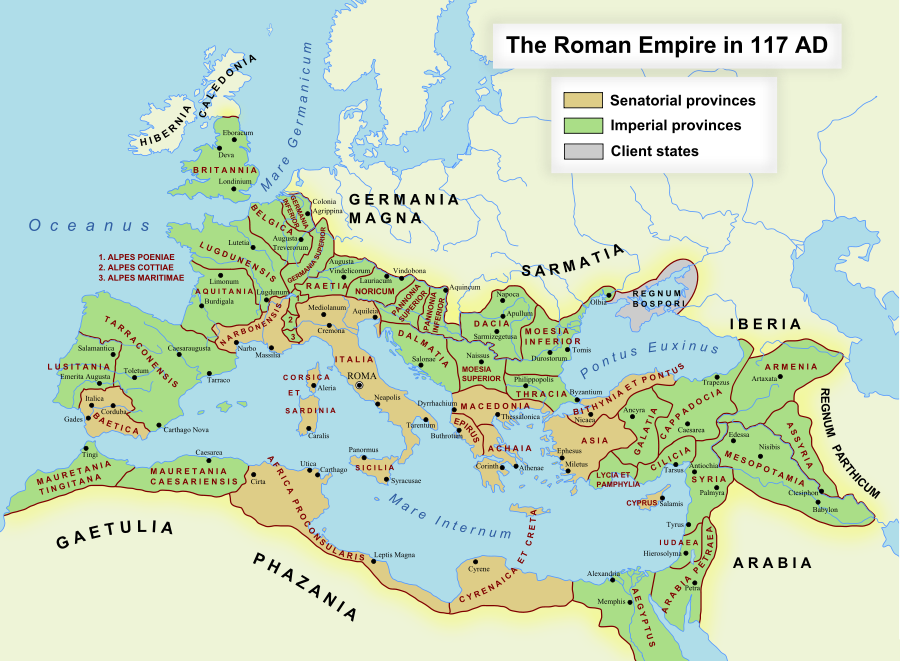
English: The maximum extent of the Roman Empire. Superimposed on a physical map. Español: Máxima extensión del Imperio Romano. Superpuesto en un mapa físico. Deutsch: Das Römische Reich zur Zeit seiner maximalen Ausdehnung unter Trajan, 117 n. Chr. Latina: Extentum maximum de Imperium Romanum. 中文:公元117年图拉真在位时期罗马帝国的最大疆域。 日本語: ローマ帝国の最大版図。(西暦117年、皇帝トラヤヌス) |
| तारीख | १७ अक्टूबर २००५ (first version); १९ दिसंबर २००७ (last version) |
| स्रोत | Transferred from en.wikipedia to Commons. |
| लेखक | ArdadN at अंगरेजी विकिपीडिया |
| परमीशन (एह फाइल के दुबारा इस्तेमाल) |
Public Domain |
| Other versions |
[]
|
| SVG genesis InfoField |


SVG Support
This document is in the Scalable Vector Graphic format (SVG) and requires a supported browser (Firefox, Google Chrome, Opera) or a SVG plugin for Internet Explorer and other browsers. SVG is an open, text-based format, which means this map can be downloaded and modified/translated completely using a vector graphics editor like Adobe Illustrator or Inkscape (free) or a text editor such as Notepad.
| BLANK THUMBNAIL | View large PNG | View medium PNG | SVG Plugin for Internet Explorer and other browsers |
|---|---|---|---|
| Click here (purge cache) and then CTRL+F5 to reload. Help? | Try 1 Try 2 | Try 1 Try 2 | Adobe SVG plugin |
| Recommended browser | More Help | ||
| Firefox | List of SVG tools |



लाइसेंसिंग
ArdadN at अंगरेजी विकिपीडिया, the copyright holder of this work, hereby publishes it under the following license:
| Public domainPublic domainfalsefalse |

|
This work has been released into the public domain by its author, ArdadN at अंगरेजी विकिपीडिया. This applies worldwide. In some countries this may not be legally possible; if so: ArdadN at अंगरेजी विकिपीडिया grants anyone the right to use this work for any purpose, without any conditions, unless such conditions are required by law. |
Captions
Add a one-line explanation of what this file represents
Map of the maximum extent of the Roman Empire
Mapa de la extensión máxima del Imperio Romano
罗马帝国的最大疆域的地图
Karte des Römische Reich zur Zeit seiner maximalen Ausdehnung
Romani Imperii amplitudo maxima
ローマ帝国の最大版図
फाइल के इतिहास
ओ समय ई फाइल कइसन लउके ई देखे खातिर कौनों तारीख/समय पर क्लिक करीं।
| तारीख/समय | चिप्पी रूप | डाइमेंशन | प्रयोगकर्ता | टिप्पणी | |
|---|---|---|---|---|---|
| वर्तमान | १७:१८, २४ नवंबर २०२२ | Error creating thumbnail: फाइल गायब बा | ५१२ × ३७६ (७०४ KB) | smartcommons>Vikarna | alpes poeniae → alpes poeninae |
फाइल के उपयोग
फाइल के इस्तेमाल पन्ना करत बा:
